Mamungan elevation
Mamungan (Northern Mindanao, Province of Lanao del Norte), Philippines elevation is 373 meters and Mamungan elevation in feet is 1224 ft above sea level [src 1]. Mamungan is a populated place (feature code) with elevation that is 285 meters (935 ft) bigger than average city elevation in Philippines.
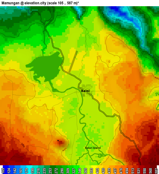
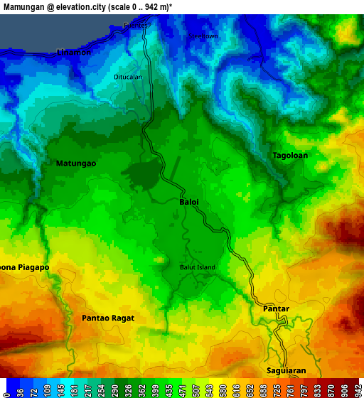
Below is the Elevation map of Mamungan, which displays elevation range with different colors. Scale of the first map is from 105 to 587 m (344 to 1926 ft) with average elevation of 387.6 meters (=1272 ft) [note 1]
These maps also provides idea of topography and contour of this city, they are displayed at different zoom levels. More info about maps, scale and edge coordinates you can find below images.
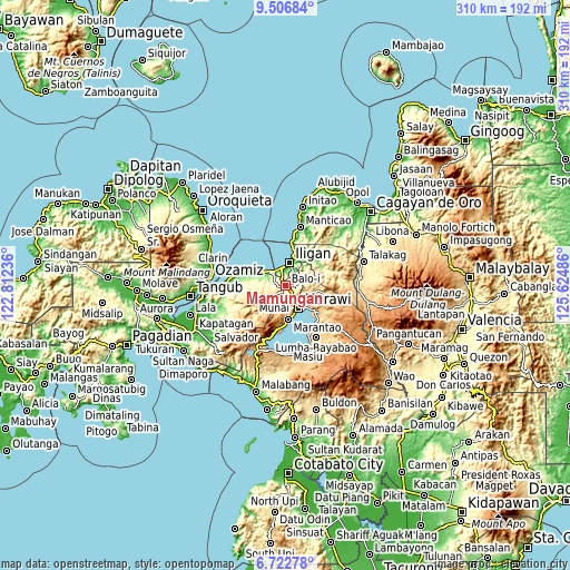
| \ | Map #1 | Map #2 | Topo.Map |
| Scale [m] | 105..587 m | 0..942 m | × |
| Scale [ft] | 344..1926 ft | 0..3091 ft | × |
| Average | 387.6 m = 1272 ft | 413 m = 1355 ft | × |
| Width | 9.67 km = 6 mi | 19.35 km = 12 mi | 309.6 km = 192.4 mi |
| Height | 9.67 km = 6 mi | 19.35 km = 12 mi | 309.6 km = 192.4 mi |
| ↑Max Latitude | 8.160723° | 8.204221° | 9.50684° |
| Latitude at center | 8.11722° | 8.11722° | 8.11722° |
| ↓Min Latitude | 8.073713° | 8.030201° | 6.72278° |
| ← Min Longitude | 124.174665° | 124.130719° | 122.81236° |
| Longitude center | 124.21861° | 124.21861° | 124.21861° |
| →Max Longitude | 124.262555° | 124.306501° | 125.62486° |
Nearby cities:
Cities around Mamungan sort by population:
• Mantampay elevation 172 m
5.5 km,  357°
357°
• Boroon 82 m
8.6 km,  327°
327°
• Linamon 7 m
9.8 km,  321°
321°
• Maria Cristina 256 m
5.7 km,  343°
343°
• Nañgka 189 m
6.7 km, 324°
• Dimayon 646 m
9.4 km,  233°
233°
• Kalanganan 507 m
4.9 km,  140°
140°
• Poona-Piagapo 523 m
11.8 km,  251°
251°
• Saguiaran 630 m
10.9 km,  148°
148°
• Pantao-Ragat 574 m
10.1 km, 248°
• Pantar 592 m
7.2 km, 142°
• Matungao 350 m
6.3 km,  289°
289°
Multilingual:
 En español:
Mamungan elevación 373 m.
 En France:
Mamungan élévation 373 m.
 Auf Deutsch:
Mamungan höhe über dem Meeresspiegel ist 373 m.

Sources and notes:
- [note 1] Map square and city borders are not equal. Map elevation data is calculated only from area inside that square.
- [src 1] Elevation data from geonames database provided with same terms of usage.
- [src 2] The elevation map of Mamungan is generated using elevation data from NASA's 3 arcsec (90m) resolution SRTM data.
- [src 3] Base (background) map © OpenStreetMap contributors tiles are generated by Geofabrik and OpenTopoMap.
Copyright & License:
This Mamungan Elevation Map is licensed under CC BY-SA. You may reuse any part from this page, if you give a proper credit by linking to this URL:
 More info on terms of use page.