Saguiaran elevation
Saguiaran (Autonomous Region in Muslim Mindanao, Province of Lanao del Sur), Philippines elevation is 630 meters and Saguiaran elevation in feet is 2067 ft above sea level [src 1]. Saguiaran is a seat of a third-order administrative division (feature code) with elevation that is 542 meters (1778 ft) bigger than average city elevation in Philippines.
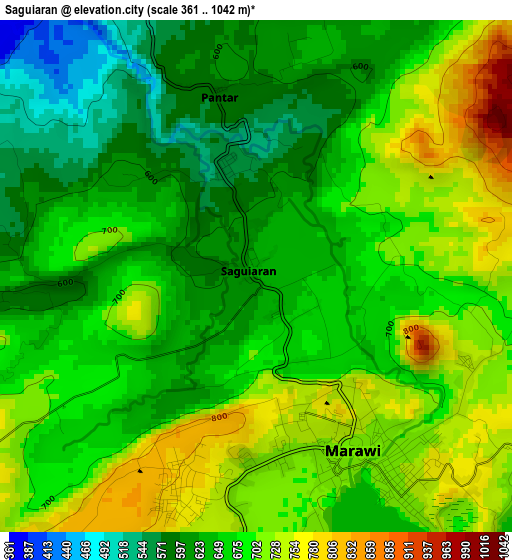
Below is the Elevation map of Saguiaran, which displays elevation range with different colors. Scale of the first map is from 361 to 1042 m (1184 to 3419 ft) with average elevation of 669.8 meters (=2198 ft) [note 1]
These maps also provides idea of topography and contour of this city, they are displayed at different zoom levels. More info about maps, scale and edge coordinates you can find below images.
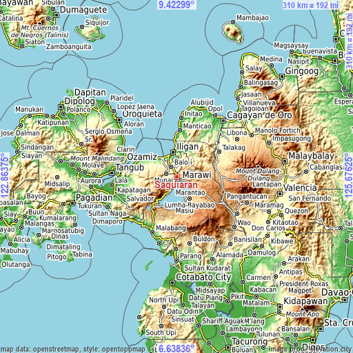
| \ | Map #1 | Topo.Map |
| Scale [m] | 361..1042 m | × |
| Scale [ft] | 1184..3419 ft | × |
| Average | 669.8 m = 2198 ft | × |
| Width | 9.68 km = 6 mi | 309.6 km = 192.4 mi |
| Height | 9.68 km = 6 mi | 309.7 km = 192.4 mi |
| ↑Max Latitude | 8.076572° | 9.42299° |
| Latitude at center | 8.03306° | 8.03306° |
| ↓Min Latitude | 7.989544° | 6.63836° |
| ← Min Longitude | 124.226055° | 122.86375° |
| Longitude center | 124.27° | 124.27° |
| →Max Longitude | 124.313945° | 125.67625° |
Nearby cities:
Cities around Saguiaran sort by population:
• Marawi City elevation 719 m
3.6 km,  155°
155°
• Mamungan 373 m
10.9 km,  328°
328°
• Marantao 716 m
10.1 km,  203°
203°
• Dimayon 646 m
13.7 km,  285°
285°
• Pawak 623 m
2.4 km,  218°
218°
• Kalanganan 507 m
6.2 km,  335°
335°
• Molundo 710 m
15.2 km,  133°
133°
• Balindong 751 m
15 km,  210°
210°
• Buadiposo-Buntong 715 m
14.5 km,  120°
120°
• Ramain 705 m
10.8 km, 129°
• Ditsaan 704 m
10.8 km, 123°
• Pantar 592 m
3.9 km, 340°
Multilingual:
 En español:
Saguiaran elevación 630 m.
 En France:
Saguiaran élévation 630 m.
 Auf Deutsch:
Saguiaran höhe über dem Meeresspiegel ist 630 m.

Sources and notes:
- [note 1] Map square and city borders are not equal. Map elevation data is calculated only from area inside that square.
- [src 1] Elevation data from geonames database provided with same terms of usage.
- [src 2] The elevation map of Saguiaran is generated using elevation data from NASA's 3 arcsec (90m) resolution SRTM data.
- [src 3] Base (background) map © OpenStreetMap contributors tiles are generated by Geofabrik and OpenTopoMap.
Copyright & License:
This Saguiaran Elevation Map is licensed under CC BY-SA. You may reuse any part from this page, if you give a proper credit by linking to this URL:
 More info on terms of use page.