Bansalan elevation
Bansalan (Davao, Province of Davao del Sur), Philippines elevation is 162 meters and Bansalan elevation in feet is 531 ft above sea level [src 1]. Bansalan is a seat of a third-order administrative division (feature code) with elevation that is 74 meters (243 ft) bigger than average city elevation in Philippines.
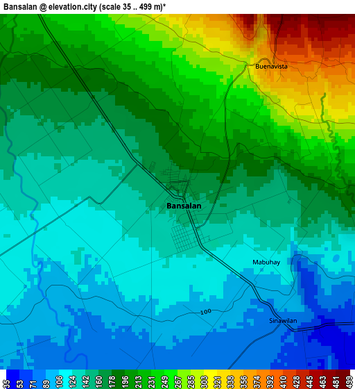
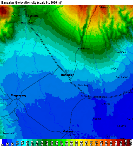
Below is the Elevation map of Bansalan, which displays elevation range with different colors. Scale of the first map is from 35 to 499 m (115 to 1637 ft) with average elevation of 171.5 meters (=563 ft) [note 1]
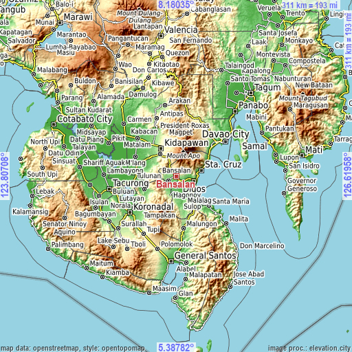
These maps also provides idea of topography and contour of this city, they are displayed at different zoom levels. More info about maps, scale and edge coordinates you can find below images.
| \ | Map #1 | Map #2 | Topo.Map |
| Scale [m] | 35..499 m | 9..1066 m | × |
| Scale [ft] | 115..1637 ft | 30..3497 ft | × |
| Average | 171.5 m = 563 ft | 224.4 m = 736 ft | × |
| Width | 9.7 km = 6 mi | 19.41 km = 12.1 mi | 310.5 km = 192.9 mi |
| Height | 9.7 km = 6 mi | 19.41 km = 12.1 mi | 310.5 km = 192.9 mi |
| ↑Max Latitude | 6.829745° | 6.873377° | 8.18035° |
| Latitude at center | 6.78611° | 6.78611° | 6.78611° |
| ↓Min Latitude | 6.742471° | 6.698827° | 5.38782° |
| ← Min Longitude | 125.169385° | 125.125439° | 123.80708° |
| Longitude center | 125.21333° | 125.21333° | 125.21333° |
| →Max Longitude | 125.257275° | 125.301221° | 126.61958° |
Nearby cities:
Cities around Bansalan sort by population:
• Digos elevation 18 m
16.4 km,  104°
104°
• Magsaysay 102 m
4 km,  236°
236°
• Matanao 42 m
12.7 km,  158°
158°
• Sinayawan 13 m
13.4 km,  127°
127°
• Matti 47 m
10.7 km, 99°
• Bulatukan 476 m
14.2 km,  335°
335°
• Goma 80 m
11.9 km,  86°
86°
• Sinawilan 60 m
5.1 km, 133°
• Dolo 177 m
3.6 km,  318°
318°
• Managa 66 m
7.5 km, 126°
• Ignit 16 m
12.9 km,  137°
137°
• Malinao 34 m
16.3 km,  150°
150°
Multilingual:
 En español:
Bansalan elevación 162 m.
 En France:
Bansalan élévation 162 m.
 Auf Deutsch:
Bansalan höhe über dem Meeresspiegel ist 162 m.

Sources and notes:
- [note 1] Map square and city borders are not equal. Map elevation data is calculated only from area inside that square.
- [src 1] Elevation data from geonames database provided with same terms of usage.
- [src 2] The elevation map of Bansalan is generated using elevation data from NASA's 3 arcsec (90m) resolution SRTM data.
- [src 3] Base (background) map © OpenStreetMap contributors tiles are generated by Geofabrik and OpenTopoMap.
Copyright & License:
This Bansalan Elevation Map is licensed under CC BY-SA. You may reuse any part from this page, if you give a proper credit by linking to this URL:
 More info on terms of use page.