Bugasan elevation
Bugasan (Autonomous Region in Muslim Mindanao, Province of Maguindanao), Philippines elevation is 122 meters and Bugasan elevation in feet is 400 ft above sea level [src 1]. Bugasan is a populated place (feature code) with elevation that is 34 meters (112 ft) bigger than average city elevation in Philippines.
Below is the Elevation map of Bugasan, which displays elevation range with different colors. Scale of the first map is from 0 to 562 m (0 to 1844 ft) with average elevation of 202.3 meters (=664 ft) [note 1]
These maps also provides idea of topography and contour of this city, they are displayed at different zoom levels. More info about maps, scale and edge coordinates you can find below images.
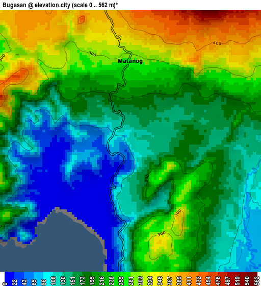
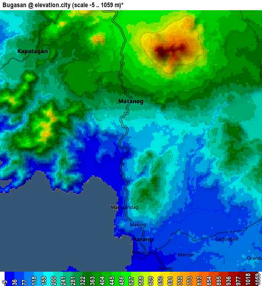
| \ | Map #1 | Map #2 | Topo.Map |
| Scale [m] | 0..562 m | -5..1059 m | × |
| Scale [ft] | 0..1844 ft | -16..3474 ft | × |
| Average | 202.3 m = 664 ft | 270.4 m = 887 ft | × |
| Width | 9.69 km = 6 mi | 19.38 km = 12 mi | 310.1 km = 192.7 mi |
| Height | 9.69 km = 6 mi | 19.38 km = 12 mi | 310.1 km = 192.7 mi |
| ↑Max Latitude | 7.484403° | 7.527972° | 8.83289° |
| Latitude at center | 7.44083° | 7.44083° | 7.44083° |
| ↓Min Latitude | 7.397253° | 7.353671° | 6.04434° |
| ← Min Longitude | 124.215225° | 124.171279° | 122.85292° |
| Longitude center | 124.25917° | 124.25917° | 124.25917° |
| →Max Longitude | 124.303115° | 124.347061° | 125.66542° |
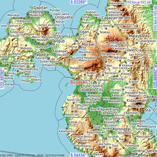
Nearby cities:
Cities around Bugasan sort by population:
• Parang elevation 57 m
7.9 km,  171°
171°
• Bayanga 490 m
9 km,  355°
355°
• Katuli 137 m
4.8 km,  259°
259°
• Sapadun 374 m
4.8 km,  347°
347°
• Barira 534 m
6.8 km,  40°
40°
• Polloc 8 m
10.6 km,  203°
203°
• Mataya 242 m
12.9 km,  74°
74°
• Bualan 157 m
1.2 km,  49°
49°
• Rominimbang 718 m
8 km,  34°
34°
• Ebcor Town 180 m
15.2 km,  90°
90°
• Buldon 401 m
14.6 km,  58°
58°
• Matanog 530 m
8.4 km, 357°
Multilingual:
 En español:
Bugasan elevación 122 m.
 En France:
Bugasan élévation 122 m.


Sources and notes:
- [note 1] Map square and city borders are not equal. Map elevation data is calculated only from area inside that square.
- [src 1] Elevation data from geonames database provided with same terms of usage.
- [src 2] The elevation map of Bugasan is generated using elevation data from NASA's 3 arcsec (90m) resolution SRTM data.
- [src 3] Base (background) map © OpenStreetMap contributors tiles are generated by Geofabrik and OpenTopoMap.
Copyright & License:
This Bugasan Elevation Map is licensed under CC BY-SA. You may reuse any part from this page, if you give a proper credit by linking to this URL:
 More info on terms of use page.