Calanasan elevation
Calanasan (Cordillera, Apayao), Philippines elevation is 320 meters and Calanasan elevation in feet is 1050 ft above sea level [src 1]. Calanasan is a seat of a third-order administrative division (feature code) with elevation that is 232 meters (761 ft) bigger than average city elevation in Philippines.
Below is the Elevation map of Calanasan, which displays elevation range with different colors. Scale of the first map is from 248 to 1211 m (814 to 3973 ft) with average elevation of 547.5 meters (=1796 ft) [note 1]
These maps also provides idea of topography and contour of this city, they are displayed at different zoom levels. More info about maps, scale and edge coordinates you can find below images.
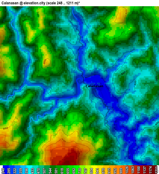
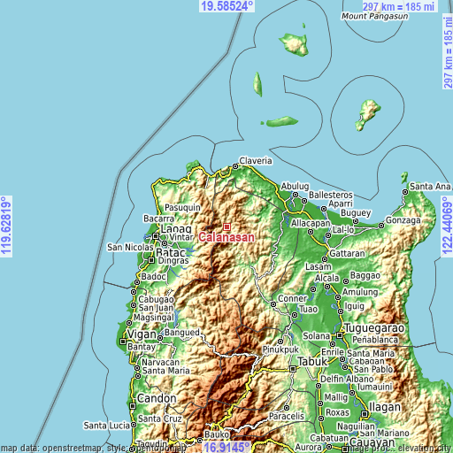
| \ | Map #1 | Topo.Map |
| Scale [m] | 248..1211 m | × |
| Scale [ft] | 814..3973 ft | × |
| Average | 547.5 m = 1796 ft | × |
| Width | 9.28 km = 5.8 mi | 297 km = 184.5 mi |
| Height | 9.28 km = 5.8 mi | 297 km = 184.5 mi |
| ↑Max Latitude | 18.296729° | 19.58524° |
| Latitude at center | 18.255° | 18.255° |
| ↓Min Latitude | 18.213261° | 16.9145° |
| ← Min Longitude | 120.990495° | 119.62819° |
| Longitude center | 121.03444° | 121.03444° |
| →Max Longitude | 121.078385° | 122.44069° |
Nearby cities:
Cities around Calanasan sort by population:
• Solsona elevation 52 m
33.2 km,  237°
237°
• Piddig 50 m
34.9 km,  253°
253°
• Padong 49 m
37.1 km,  232°
232°
• Calog Norte 10 m
39 km,  71°
71°
• Barong 47 m
38.6 km, 235°
• Kabugao 103 m
30.7 km,  149°
149°
• Bagu 8 m
38.8 km,  60°
60°
• Dumalneg 54 m
38.3 km,  321°
321°
• Santa Praxedes 285 m
34.8 km,  354°
354°
• Luna 90 m
34.6 km,  76°
76°
• Adams 236 m
27.5 km,  328°
328°
• Carasi 428 m
18.6 km, 250°
Multilingual:
 En español:
Calanasan elevación 320 m.
 En France:
Calanasan élévation 320 m.
 Auf Deutsch:
Calanasan höhe über dem Meeresspiegel ist 320 m.

Sources and notes:
- [note 1] Map square and city borders are not equal. Map elevation data is calculated only from area inside that square.
- [src 1] Elevation data from geonames database provided with same terms of usage.
- [src 2] The elevation map of Calanasan is generated using elevation data from NASA's 3 arcsec (90m) resolution SRTM data.
- [src 3] Base (background) map © OpenStreetMap contributors tiles are generated by Geofabrik and OpenTopoMap.
Copyright & License:
This Calanasan Elevation Map is licensed under CC BY-SA. You may reuse any part from this page, if you give a proper credit by linking to this URL:
 More info on terms of use page.