Kabugao elevation
Kabugao (Cordillera, Apayao), Philippines elevation is 103 meters and Kabugao elevation in feet is 338 ft above sea level [src 1]. Kabugao is a seat of a third-order administrative division (feature code) with elevation that is 15 meters (49 ft) bigger than average city elevation in Philippines.
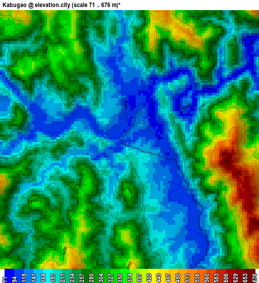
Below is the Elevation map of Kabugao, which displays elevation range with different colors. Scale of the first map is from 71 to 676 m (233 to 2218 ft) with average elevation of 248.7 meters (=816 ft) [note 1]
These maps also provides idea of topography and contour of this city, they are displayed at different zoom levels. More info about maps, scale and edge coordinates you can find below images.
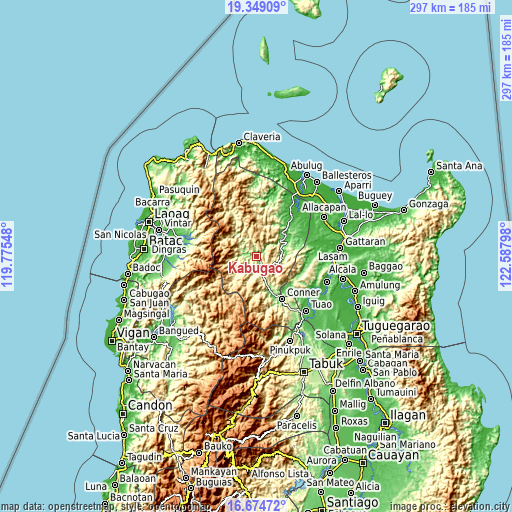
| \ | Map #1 | Topo.Map |
| Scale [m] | 71..676 m | × |
| Scale [ft] | 233..2218 ft | × |
| Average | 248.7 m = 816 ft | × |
| Width | 9.29 km = 5.8 mi | 297.4 km = 184.8 mi |
| Height | 9.29 km = 5.8 mi | 297.4 km = 184.8 mi |
| ↑Max Latitude | 18.058765° | 19.34909° |
| Latitude at center | 18.01698° | 18.01698° |
| ↓Min Latitude | 17.975185° | 16.67472° |
| ← Min Longitude | 121.137785° | 119.77548° |
| Longitude center | 121.18173° | 121.18173° |
| →Max Longitude | 121.225675° | 122.58798° |
Nearby cities:
Cities around Kabugao sort by population:
• Piat elevation 56 m
40.2 km,  128°
128°
• Flora 73 m
33.4 km,  48°
48°
• Nabannagan West 22 m
38 km,  80°
80°
• Conner 88 m
29 km,  147°
147°
• Accusilian 38 m
42.2 km,  135°
135°
• Tuao 37 m
42.6 km, 137°
• Alannay 16 m
43 km, 83°
• Santa Marcela 13 m
39.8 km,  41°
41°
• Carasi 428 m
38.8 km,  301°
301°
• Luna 90 m
38.8 km,  27°
27°
• Calanasan 320 m
30.7 km,  329°
329°
• Rizal 88 m
25.6 km, 137°
Multilingual:
 En español:
Kabugao elevación 103 m.
 En France:
Kabugao élévation 103 m.


Sources and notes:
- [note 1] Map square and city borders are not equal. Map elevation data is calculated only from area inside that square.
- [src 1] Elevation data from geonames database provided with same terms of usage.
- [src 2] The elevation map of Kabugao is generated using elevation data from NASA's 3 arcsec (90m) resolution SRTM data.
- [src 3] Base (background) map © OpenStreetMap contributors tiles are generated by Geofabrik and OpenTopoMap.
Copyright & License:
This Kabugao Elevation Map is licensed under CC BY-SA. You may reuse any part from this page, if you give a proper credit by linking to this URL:
 More info on terms of use page.