Dinalupihan elevation
Dinalupihan (Central Luzon, Province of Bataan), Philippines elevation is 9 meters and Dinalupihan elevation in feet is 30 ft above sea level [src 1]. Dinalupihan is a seat of a third-order administrative division (feature code) with elevation that is 79 meters (259 ft) smaller than average city elevation in Philippines.
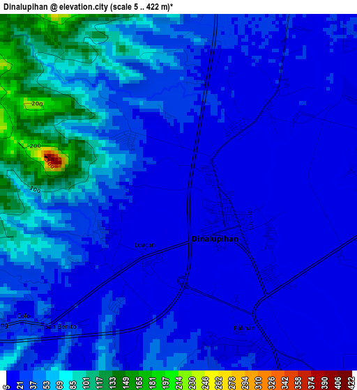
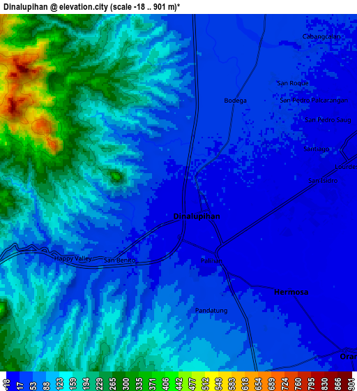
Below is the Elevation map of Dinalupihan, which displays elevation range with different colors. Scale of the first map is from 5 to 422 m (16 to 1385 ft) with average elevation of 39.2 meters (=129 ft) [note 1]
These maps also provides idea of topography and contour of this city, they are displayed at different zoom levels. More info about maps, scale and edge coordinates you can find below images.
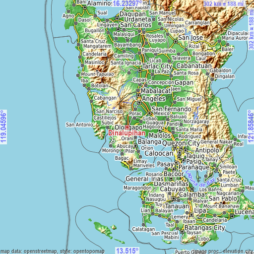
| \ | Map #1 | Map #2 | Topo.Map |
| Scale [m] | 5..422 m | -18..901 m | × |
| Scale [ft] | 16..1385 ft | -59..2956 ft | × |
| Average | 39.2 m = 129 ft | 100.8 m = 331 ft | × |
| Width | 9.44 km = 5.9 mi | 18.89 km = 11.7 mi | 302.2 km = 187.8 mi |
| Height | 9.44 km = 5.9 mi | 18.89 km = 11.7 mi | 302.2 km = 187.8 mi |
| ↑Max Latitude | 14.920738° | 14.963197° | 16.23297° |
| Latitude at center | 14.87827° | 14.87827° | 14.87827° |
| ↓Min Latitude | 14.835794° | 14.793309° | 13.515° |
| ← Min Longitude | 120.408265° | 120.364319° | 119.04596° |
| Longitude center | 120.45221° | 120.45221° | 120.45221° |
| →Max Longitude | 120.496155° | 120.540101° | 121.85846° |
Nearby cities:
Cities around Dinalupihan sort by population:
• Orani elevation 9 m
12.6 km,  133°
133°
• Hermosa 12 m
8 km, 130°
• Santa Cruz 8 m
12.9 km,  72°
72°
• Santiago 18 m
7 km, 66°
• Balsic 14 m
3.9 km,  123°
123°
• Santa Teresa First 11 m
12.6 km,  64°
64°
• San Francisco 22 m
13.6 km,  47°
47°
• Prado Siongco 16 m
6.5 km,  89°
89°
• Gutad 23 m
6.8 km,  36°
36°
• San Benito 20 m
4 km,  222°
222°
• Calangain 6 m
11.7 km,  79°
79°
• Bodega 24 m
5.8 km,  30°
30°
Multilingual:
 En español:
Dinalupihan elevación 9 m.
 En France:
Dinalupihan élévation 9 m.
 Auf Deutsch:
Dinalupihan höhe über dem Meeresspiegel ist 9 m.

Sources and notes:
- [note 1] Map square and city borders are not equal. Map elevation data is calculated only from area inside that square.
- [src 1] Elevation data from geonames database provided with same terms of usage.
- [src 2] The elevation map of Dinalupihan is generated using elevation data from NASA's 3 arcsec (90m) resolution SRTM data.
- [src 3] Base (background) map © OpenStreetMap contributors tiles are generated by Geofabrik and OpenTopoMap.
Copyright & License:
This Dinalupihan Elevation Map is licensed under CC BY-SA. You may reuse any part from this page, if you give a proper credit by linking to this URL:
 More info on terms of use page.