Dinganen elevation
Dinganen (Autonomous Region in Muslim Mindanao, Province of Maguindanao), Philippines elevation is 136 meters and Dinganen elevation in feet is 446 ft above sea level [src 1]. Dinganen is a populated place (feature code) with elevation that is 48 meters (157 ft) bigger than average city elevation in Philippines.
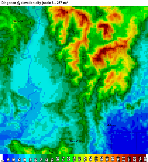
Below is the Elevation map of Dinganen, which displays elevation range with different colors. Scale of the first map is from 6 to 257 m (20 to 843 ft) with average elevation of 85.8 meters (=281 ft) [note 1]
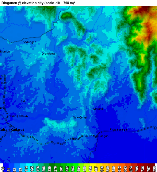
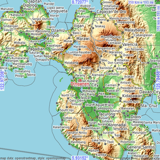
These maps also provides idea of topography and contour of this city, they are displayed at different zoom levels. More info about maps, scale and edge coordinates you can find below images.
| \ | Map #1 | Map #2 | Topo.Map |
| Scale [m] | 6..257 m | -10..798 m | × |
| Scale [ft] | 20..843 ft | -33..2618 ft | × |
| Average | 85.8 m = 281 ft | 99.3 m = 326 ft | × |
| Width | 9.69 km = 6 mi | 19.39 km = 12 mi | 310.1 km = 192.7 mi |
| Height | 9.69 km = 6 mi | 19.39 km = 12 mi | 310.2 km = 192.7 mi |
| ↑Max Latitude | 7.371914° | 7.415494° | 8.72077° |
| Latitude at center | 7.32833° | 7.32833° | 7.32833° |
| ↓Min Latitude | 7.284742° | 7.241149° | 5.93152° |
| ← Min Longitude | 124.334385° | 124.290439° | 122.97208° |
| Longitude center | 124.37833° | 124.37833° | 124.37833° |
| →Max Longitude | 124.422275° | 124.466221° | 125.78458° |
Nearby cities:
Cities around Dinganen sort by population:
• Budta elevation 4 m
15.4 km,  153°
153°
• Parang 57 m
12.9 km,  291°
291°
• Pigcawayan 19 m
7.7 km,  137°
137°
• Dalumangcob 3 m
15.1 km,  214°
214°
• Simuay 51 m
9.7 km,  234°
234°
• Manuangan 10 m
6.4 km, 153°
• Tapayan 15 m
12.9 km,  253°
253°
• Balogo 34 m
10.7 km,  118°
118°
• Ebcor Town 180 m
12.7 km,  9°
9°
• Baka 20 m
13.9 km, 245°
• Pinaring 10 m
13.3 km, 214°
• Nuyo 129 m
10.6 km,  19°
19°
Multilingual:
 En español:
Dinganen elevación 136 m.
 En France:
Dinganen élévation 136 m.
 Auf Deutsch:
Dinganen höhe über dem Meeresspiegel ist 136 m.

Sources and notes:
- [note 1] Map square and city borders are not equal. Map elevation data is calculated only from area inside that square.
- [src 1] Elevation data from geonames database provided with same terms of usage.
- [src 2] The elevation map of Dinganen is generated using elevation data from NASA's 3 arcsec (90m) resolution SRTM data.
- [src 3] Base (background) map © OpenStreetMap contributors tiles are generated by Geofabrik and OpenTopoMap.
Copyright & License:
This Dinganen Elevation Map is licensed under CC BY-SA. You may reuse any part from this page, if you give a proper credit by linking to this URL:
 More info on terms of use page.