Imbatug elevation
Imbatug (Northern Mindanao, Province of Bukidnon), Philippines elevation is 398 meters and Imbatug elevation in feet is 1306 ft above sea level [src 1]. Imbatug is a populated place (feature code) with elevation that is 310 meters (1017 ft) bigger than average city elevation in Philippines.
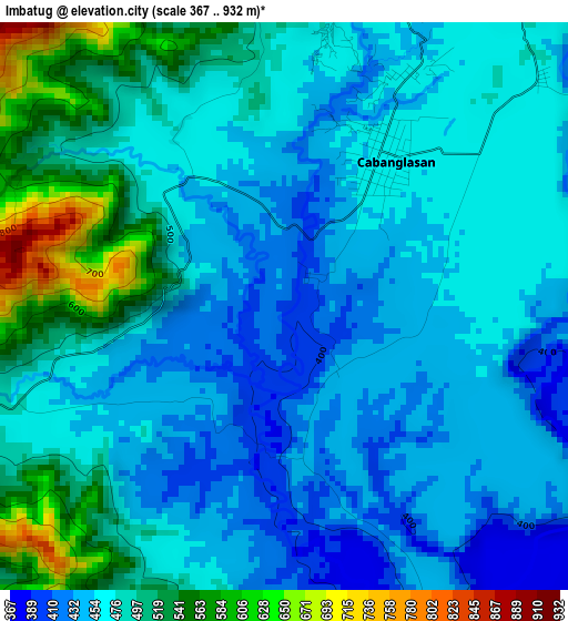
Below is the Elevation map of Imbatug, which displays elevation range with different colors. Scale of the first map is from 367 to 932 m (1204 to 3058 ft) with average elevation of 476.1 meters (=1562 ft) [note 1]
These maps also provides idea of topography and contour of this city, they are displayed at different zoom levels. More info about maps, scale and edge coordinates you can find below images.
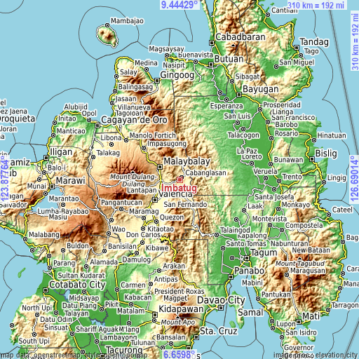
| \ | Map #1 | Topo.Map |
| Scale [m] | 367..932 m | × |
| Scale [ft] | 1204..3058 ft | × |
| Average | 476.1 m = 1562 ft | × |
| Width | 9.68 km = 6 mi | 309.6 km = 192.4 mi |
| Height | 9.68 km = 6 mi | 309.6 km = 192.4 mi |
| ↑Max Latitude | 8.097949° | 9.44429° |
| Latitude at center | 8.05444° | 8.05444° |
| ↓Min Latitude | 8.010926° | 6.6598° |
| ← Min Longitude | 125.239945° | 123.87764° |
| Longitude center | 125.28389° | 125.28389° |
| →Max Longitude | 125.327835° | 126.69014° |
Nearby cities:
Cities around Imbatug sort by population:
• Halapitan elevation 385 m
16.1 km,  161°
161°
• Managok 346 m
10.9 km,  254°
254°
• Linabo 359 m
14.2 km,  269°
269°
• Aglayan 403 m
16.5 km, 270°
• Cabanglasan 479 m
8.9 km,  32°
32°
• Little Baguio 878 m
17.9 km,  182°
182°
• Lumbayao 327 m
13.6 km, 251°
• Cabangahan 369 m
16.5 km,  257°
257°
• Kabulohan 400 m
1.5 km,  212°
212°
• Maglamin 461 m
2.5 km, 263°
• Silae 510 m
11.6 km,  359°
359°
• Laguitas 541 m
17.3 km,  282°
282°
Multilingual:
 En español:
Imbatug elevación 398 m.
 En France:
Imbatug élévation 398 m.


Sources and notes:
- [note 1] Map square and city borders are not equal. Map elevation data is calculated only from area inside that square.
- [src 1] Elevation data from geonames database provided with same terms of usage.
- [src 2] The elevation map of Imbatug is generated using elevation data from NASA's 3 arcsec (90m) resolution SRTM data.
- [src 3] Base (background) map © OpenStreetMap contributors tiles are generated by Geofabrik and OpenTopoMap.
Copyright & License:
This Imbatug Elevation Map is licensed under CC BY-SA. You may reuse any part from this page, if you give a proper credit by linking to this URL:
 More info on terms of use page.