Lambayong elevation
Lambayong (Soccsksargen, Province of South Cotabato), Philippines elevation is 810 meters and Lambayong elevation in feet is 2657 ft above sea level [src 1]. Lambayong is a populated place (feature code) with elevation that is 722 meters (2369 ft) bigger than average city elevation in Philippines.
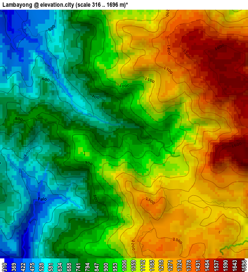
Below is the Elevation map of Lambayong, which displays elevation range with different colors. Scale of the first map is from 316 to 1696 m (1037 to 5564 ft) with average elevation of 979 meters (=3212 ft) [note 1]
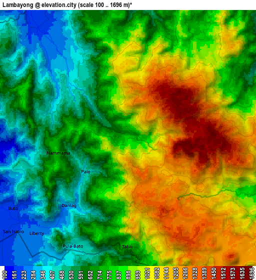
These maps also provides idea of topography and contour of this city, they are displayed at different zoom levels. More info about maps, scale and edge coordinates you can find below images.
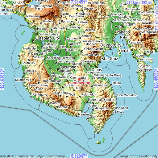
| \ | Map #1 | Map #2 | Topo.Map |
| Scale [m] | 316..1696 m | 100..1696 m | × |
| Scale [ft] | 1037..5564 ft | 328..5564 ft | × |
| Average | 979 m = 3212 ft | 825.1 m = 2707 ft | × |
| Width | 9.71 km = 6 mi | 19.42 km = 12.1 mi | 310.7 km = 193.1 mi |
| Height | 9.71 km = 6 mi | 19.42 km = 12.1 mi | 310.7 km = 193.1 mi |
| ↑Max Latitude | 6.563099° | 6.606755° | 7.91451° |
| Latitude at center | 6.51944° | 6.51944° | 6.51944° |
| ↓Min Latitude | 6.475777° | 6.43211° | 5.12047° |
| ← Min Longitude | 125.000495° | 124.956549° | 123.63819° |
| Longitude center | 125.04444° | 125.04444° | 125.04444° |
| →Max Longitude | 125.088385° | 125.132331° | 126.45069° |
Nearby cities:
Cities around Lambayong sort by population:
• Tampakan elevation 1230 m
5.3 km,  127°
127°
• Tamnag 48 m
19.1 km,  288°
288°
• Cebuano 247 m
16.9 km,  209°
209°
• Kipalbig 143 m
17.8 km,  227°
227°
• Blingkong 47 m
18.7 km, 294°
• Maltana 153 m
16 km, 227°
• Linan 273 m
12.3 km,  217°
217°
• Mabini 79 m
15.1 km,  264°
264°
• Rotonda 74 m
17.8 km, 260°
• Telafas 160 m
14.6 km,  327°
327°
• Lampitak 739 m
9.7 km,  174°
174°
• Liberty 250 m
9.9 km, 223°
Multilingual:
 En español:
Lambayong elevación 810 m.
 En France:
Lambayong élévation 810 m.
 Auf Deutsch:
Lambayong höhe über dem Meeresspiegel ist 810 m.

Sources and notes:
- [note 1] Map square and city borders are not equal. Map elevation data is calculated only from area inside that square.
- [src 1] Elevation data from geonames database provided with same terms of usage.
- [src 2] The elevation map of Lambayong is generated using elevation data from NASA's 3 arcsec (90m) resolution SRTM data.
- [src 3] Base (background) map © OpenStreetMap contributors tiles are generated by Geofabrik and OpenTopoMap.
Copyright & License:
This Lambayong Elevation Map is licensed under CC BY-SA. You may reuse any part from this page, if you give a proper credit by linking to this URL:
 More info on terms of use page.