Lamut elevation
Lamut (Cordillera, Province of Ifugao), Philippines elevation is 220 meters and Lamut elevation in feet is 722 ft above sea level [src 1]. Lamut is a seat of a third-order administrative division (feature code) with elevation that is 132 meters (433 ft) bigger than average city elevation in Philippines.
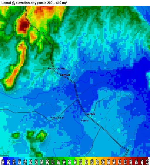
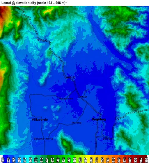
Below is the Elevation map of Lamut, which displays elevation range with different colors. Scale of the first map is from 200 to 410 m (656 to 1345 ft) with average elevation of 239.5 meters (=786 ft) [note 1]
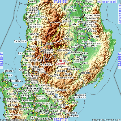
These maps also provides idea of topography and contour of this city, they are displayed at different zoom levels. More info about maps, scale and edge coordinates you can find below images.
| \ | Map #1 | Map #2 | Topo.Map |
| Scale [m] | 200..410 m | 193..998 m | × |
| Scale [ft] | 656..1345 ft | 633..3274 ft | × |
| Average | 239.5 m = 786 ft | 310.1 m = 1017 ft | × |
| Width | 9.36 km = 5.8 mi | 18.73 km = 11.6 mi | 299.6 km = 186.2 mi |
| Height | 9.36 km = 5.8 mi | 18.73 km = 11.6 mi | 299.6 km = 186.2 mi |
| ↑Max Latitude | 16.691168° | 16.733258° | 17.99152° |
| Latitude at center | 16.64907° | 16.64907° | 16.64907° |
| ↓Min Latitude | 16.606962° | 16.564845° | 15.29715° |
| ← Min Longitude | 121.180795° | 121.136849° | 119.81849° |
| Longitude center | 121.22474° | 121.22474° | 121.22474° |
| →Max Longitude | 121.268685° | 121.312631° | 122.63099° |
Nearby cities:
Cities around Lamut sort by population:
• Solano elevation 264 m
15.2 km,  197°
197°
• Baggabag B 259 m
16.3 km,  193°
193°
• Diadi 276 m
16.7 km,  59°
59°
• Quezon 270 m
17.2 km,  164°
164°
• Bintawan 244 m
9 km,  205°
205°
• Ibung 242 m
6 km,  222°
222°
• Tuao 233 m
7.6 km,  152°
152°
• Uddiawan 291 m
12.7 km, 217°
• Buliwao 299 m
18.5 km,  177°
177°
• Baguinge 596 m
19.1 km,  318°
318°
• Villa Verde 257 m
6.8 km, 215°
• Bagabag 228 m
5.7 km, 146°
Multilingual:
 En español:
Lamut elevación 220 m.
 En France:
Lamut élévation 220 m.


Sources and notes:
- [note 1] Map square and city borders are not equal. Map elevation data is calculated only from area inside that square.
- [src 1] Elevation data from geonames database provided with same terms of usage.
- [src 2] The elevation map of Lamut is generated using elevation data from NASA's 3 arcsec (90m) resolution SRTM data.
- [src 3] Base (background) map © OpenStreetMap contributors tiles are generated by Geofabrik and OpenTopoMap.
Copyright & License:
This Lamut Elevation Map is licensed under CC BY-SA. You may reuse any part from this page, if you give a proper credit by linking to this URL:
 More info on terms of use page.