La Paz elevation
La Paz (Cagayan Valley, Province of Isabela), Philippines elevation is 65 meters and La Paz elevation in feet is 213 ft above sea level [src 1]. La Paz is a populated place (feature code) with elevation that is 23 meters (75 ft) smaller than average city elevation in Philippines.
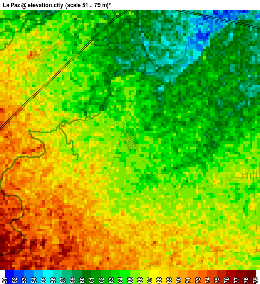
Below is the Elevation map of La Paz, which displays elevation range with different colors. Scale of the first map is from 51 to 79 m (167 to 259 ft) with average elevation of 65.6 meters (=215 ft) [note 1]
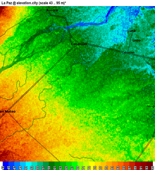
These maps also provides idea of topography and contour of this city, they are displayed at different zoom levels. More info about maps, scale and edge coordinates you can find below images.
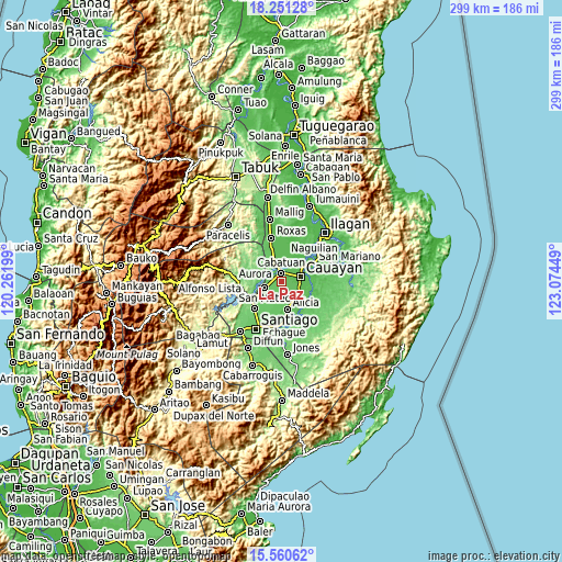
| \ | Map #1 | Map #2 | Topo.Map |
| Scale [m] | 51..79 m | 43..95 m | × |
| Scale [ft] | 167..259 ft | 141..312 ft | × |
| Average | 65.6 m = 215 ft | 66.7 m = 219 ft | × |
| Width | 9.35 km = 5.8 mi | 18.7 km = 11.6 mi | 299.2 km = 185.9 mi |
| Height | 9.35 km = 5.8 mi | 18.7 km = 11.6 mi | 299.2 km = 185.9 mi |
| ↑Max Latitude | 16.95279° | 16.994821° | 18.25128° |
| Latitude at center | 16.91075° | 16.91075° | 16.91075° |
| ↓Min Latitude | 16.8687° | 16.826641° | 15.56062° |
| ← Min Longitude | 121.624295° | 121.580349° | 120.26199° |
| Longitude center | 121.66824° | 121.66824° | 121.66824° |
| →Max Longitude | 121.712185° | 121.756131° | 123.07449° |
Nearby cities:
Cities around La Paz sort by population:
• San Mateo elevation 82 m
9.2 km,  249°
249°
• Salinungan Proper 80 m
7.4 km,  230°
230°
• Minante Segundo 63 m
10 km,  95°
95°
• Aurora 63 m
9.5 km,  339°
339°
• Nagrumbuan 67 m
4.6 km,  105°
105°
• Pinoma 69 m
5.8 km,  134°
134°
• Sillawit 62 m
10.5 km, 113°
• Luna 57 m
9.2 km,  44°
44°
• Bagong Tanza 70 m
10 km,  322°
322°
• Diamantina 72 m
4.5 km,  280°
280°
• Magdalena 64 m
4.6 km,  356°
356°
• Cabatuan 61 m
5.1 km,  0°
0°
Multilingual:
 En español:
La Paz elevación 65 m.
 En France:
La Paz élévation 65 m.


Sources and notes:
- [note 1] Map square and city borders are not equal. Map elevation data is calculated only from area inside that square.
- [src 1] Elevation data from geonames database provided with same terms of usage.
- [src 2] The elevation map of La Paz is generated using elevation data from NASA's 3 arcsec (90m) resolution SRTM data.
- [src 3] Base (background) map © OpenStreetMap contributors tiles are generated by Geofabrik and OpenTopoMap.
Copyright & License:
This La Paz Elevation Map is licensed under CC BY-SA. You may reuse any part from this page, if you give a proper credit by linking to this URL:
 More info on terms of use page.