Laya elevation
Laya (Cordillera, Kalinga), Philippines elevation is 142 meters and Laya elevation in feet is 466 ft above sea level [src 1]. Laya is a populated place (feature code) with elevation that is 54 meters (177 ft) bigger than average city elevation in Philippines.
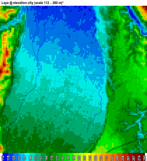
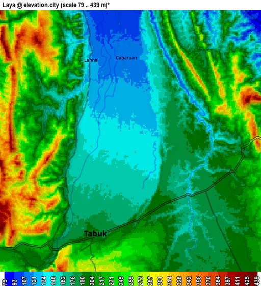
Below is the Elevation map of Laya, which displays elevation range with different colors. Scale of the first map is from 112 to 280 m (367 to 919 ft) with average elevation of 156.9 meters (=515 ft) [note 1]
These maps also provides idea of topography and contour of this city, they are displayed at different zoom levels. More info about maps, scale and edge coordinates you can find below images.
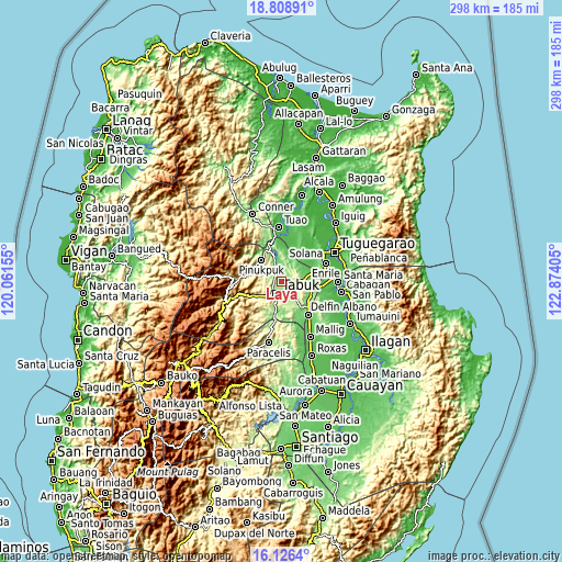
| \ | Map #1 | Map #2 | Topo.Map |
| Scale [m] | 112..280 m | 79..439 m | × |
| Scale [ft] | 367..919 ft | 259..1440 ft | × |
| Average | 156.9 m = 515 ft | 201.8 m = 662 ft | × |
| Width | 9.32 km = 5.8 mi | 18.64 km = 11.6 mi | 298.3 km = 185.4 mi |
| Height | 9.32 km = 5.8 mi | 18.64 km = 11.6 mi | 298.3 km = 185.4 mi |
| ↑Max Latitude | 17.514513° | 17.556416° | 18.80891° |
| Latitude at center | 17.4726° | 17.4726° | 17.4726° |
| ↓Min Latitude | 17.430677° | 17.388745° | 16.1264° |
| ← Min Longitude | 121.423855° | 121.379909° | 120.06155° |
| Longitude center | 121.4678° | 121.4678° | 121.4678° |
| →Max Longitude | 121.511745° | 121.555691° | 122.87405° |
Nearby cities:
Cities around Laya sort by population:
• Tabuk elevation 141 m
0.1 km,  8°
8°
• Enrile 29 m
26.2 km,  68°
68°
• Quezon 116 m
23.1 km,  140°
140°
• Liwan 64 m
18.2 km, 73°
• Paracelis 223 m
22.9 km,  180°
180°
• Agbannawag 199 m
13.7 km, 141°
• Gadu 36 m
23.1 km,  40°
40°
• Abut 130 m
19.3 km,  132°
132°
• Dagupan 41 m
25.6 km, 8°
• Lallayug 49 m
26.2 km,  353°
353°
• Tabuk 316 m
21.3 km,  250°
250°
• Pinukpuk 74 m
17.6 km,  335°
335°
Multilingual:
 En español:
Laya elevación 142 m.
 En France:
Laya élévation 142 m.


Sources and notes:
- [note 1] Map square and city borders are not equal. Map elevation data is calculated only from area inside that square.
- [src 1] Elevation data from geonames database provided with same terms of usage.
- [src 2] The elevation map of Laya is generated using elevation data from NASA's 3 arcsec (90m) resolution SRTM data.
- [src 3] Base (background) map © OpenStreetMap contributors tiles are generated by Geofabrik and OpenTopoMap.
Copyright & License:
This Laya Elevation Map is licensed under CC BY-SA. You may reuse any part from this page, if you give a proper credit by linking to this URL:
 More info on terms of use page.