Liwan elevation
Liwan (Cordillera, Kalinga), Philippines elevation is 64 meters and Liwan elevation in feet is 210 ft above sea level [src 1]. Liwan is a populated place (feature code) with elevation that is 24 meters (79 ft) smaller than average city elevation in Philippines.
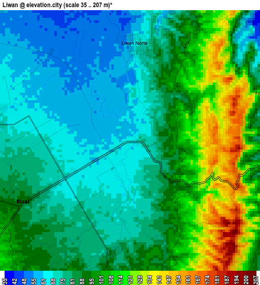
Below is the Elevation map of Liwan, which displays elevation range with different colors. Scale of the first map is from 35 to 207 m (115 to 679 ft) with average elevation of 87.6 meters (=287 ft) [note 1]
These maps also provides idea of topography and contour of this city, they are displayed at different zoom levels. More info about maps, scale and edge coordinates you can find below images.
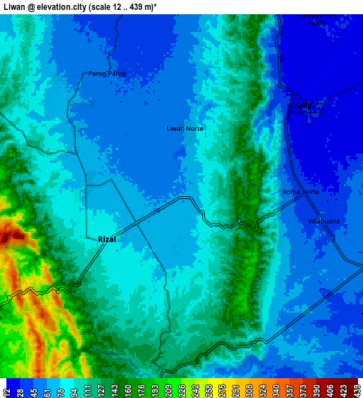
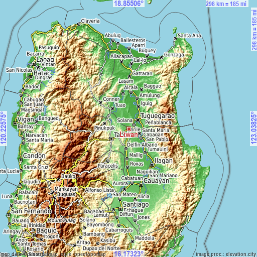
| \ | Map #1 | Map #2 | Topo.Map |
| Scale [m] | 35..207 m | 12..439 m | × |
| Scale [ft] | 115..679 ft | 39..1440 ft | × |
| Average | 87.6 m = 287 ft | 91.9 m = 302 ft | × |
| Width | 9.32 km = 5.8 mi | 18.64 km = 11.6 mi | 298.2 km = 185.3 mi |
| Height | 9.32 km = 5.8 mi | 18.64 km = 11.6 mi | 298.2 km = 185.3 mi |
| ↑Max Latitude | 17.561002° | 17.602895° | 18.85506° |
| Latitude at center | 17.5191° | 17.5191° | 17.5191° |
| ↓Min Latitude | 17.477188° | 17.435267° | 16.17323° |
| ← Min Longitude | 121.588055° | 121.544109° | 120.22575° |
| Longitude center | 121.632° | 121.632° | 121.632° |
| →Max Longitude | 121.675945° | 121.719891° | 123.03825° |
Nearby cities:
Cities around Liwan sort by population:
• Tuguegarao elevation 28 m
14.4 km,  41°
41°
• Solana 28 m
16.1 km,  22°
22°
• Enrile 29 m
8.3 km,  56°
56°
• Santa Maria 33 m
14 km,  114°
114°
• Gadu 36 m
12.5 km,  349°
349°
• Calamagui East 31 m
14.9 km,  103°
103°
• Magalalag 28 m
12.7 km, 59°
• Mozzozzin Sur 42 m
13.9 km,  119°
119°
• Bangad 30 m
15.6 km, 99°
• Ugac Sur 27 m
13.7 km, 40°
• Maddarulug Norte 53 m
10.9 km,  25°
25°
• Divisoria 35 m
15.1 km,  88°
88°
Multilingual:
 En español:
Liwan elevación 64 m.
 En France:
Liwan élévation 64 m.


Sources and notes:
- [note 1] Map square and city borders are not equal. Map elevation data is calculated only from area inside that square.
- [src 1] Elevation data from geonames database provided with same terms of usage.
- [src 2] The elevation map of Liwan is generated using elevation data from NASA's 3 arcsec (90m) resolution SRTM data.
- [src 3] Base (background) map © OpenStreetMap contributors tiles are generated by Geofabrik and OpenTopoMap.
Copyright & License:
This Liwan Elevation Map is licensed under CC BY-SA. You may reuse any part from this page, if you give a proper credit by linking to this URL:
 More info on terms of use page.