Lucsuhin elevation
Lucsuhin (Calabarzon, Province of Batangas), Philippines elevation is 14 meters and Lucsuhin elevation in feet is 46 ft above sea level [src 1]. Lucsuhin is a populated place (feature code) with elevation that is 74 meters (243 ft) smaller than average city elevation in Philippines.
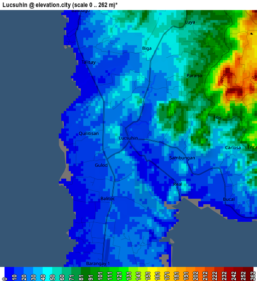
Below is the Elevation map of Lucsuhin, which displays elevation range with different colors. Scale of the first map is from 0 to 262 m (0 to 860 ft) with average elevation of 45.5 meters (=149 ft) [note 1]
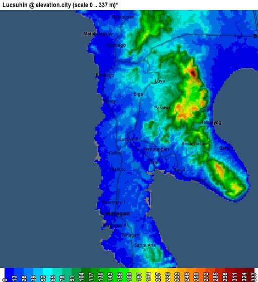
These maps also provides idea of topography and contour of this city, they are displayed at different zoom levels. More info about maps, scale and edge coordinates you can find below images.
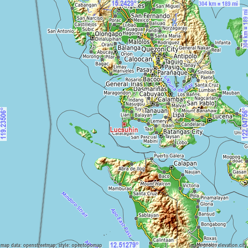
| \ | Map #1 | Map #2 | Topo.Map |
| Scale [m] | 0..262 m | 0..337 m | × |
| Scale [ft] | 0..860 ft | 0..1106 ft | × |
| Average | 45.5 m = 149 ft | 48.8 m = 160 ft | × |
| Width | 9.49 km = 5.9 mi | 18.97 km = 11.8 mi | 303.6 km = 188.6 mi |
| Height | 9.49 km = 5.9 mi | 18.97 km = 11.8 mi | 303.6 km = 188.6 mi |
| ↑Max Latitude | 13.924518° | 13.967168° | 15.2429° |
| Latitude at center | 13.88186° | 13.88186° | 13.88186° |
| ↓Min Latitude | 13.839194° | 13.796521° | 12.51279° |
| ← Min Longitude | 120.597365° | 120.553419° | 119.23506° |
| Longitude center | 120.64131° | 120.64131° | 120.64131° |
| →Max Longitude | 120.685255° | 120.729201° | 122.04756° |
Nearby cities:
Cities around Lucsuhin sort by population:
• Balayan elevation 8 m
11.6 km,  57°
57°
• Calatagan 13 m
5.6 km,  190°
190°
• Binubusan 13 m
9.8 km,  356°
356°
• Putol 55 m
15.4 km,  37°
37°
• Prinza 37 m
12.9 km,  6°
6°
• Balibago 13 m
5.2 km,  340°
340°
• Bungahan 52 m
7.1 km,  18°
18°
• Balitoc 21 m
2.2 km,  196°
196°
• Biga 33 m
2.6 km, 18°
• Gulod 24 m
1.1 km,  228°
228°
• Talisay 11 m
4.2 km,  332°
332°
• Hukay 11 m
7.8 km,  121°
121°
Multilingual:
 En español:
Lucsuhin elevación 14 m.
 En France:
Lucsuhin élévation 14 m.


Sources and notes:
- [note 1] Map square and city borders are not equal. Map elevation data is calculated only from area inside that square.
- [src 1] Elevation data from geonames database provided with same terms of usage.
- [src 2] The elevation map of Lucsuhin is generated using elevation data from NASA's 3 arcsec (90m) resolution SRTM data.
- [src 3] Base (background) map © OpenStreetMap contributors tiles are generated by Geofabrik and OpenTopoMap.
Copyright & License:
This Lucsuhin Elevation Map is licensed under CC BY-SA. You may reuse any part from this page, if you give a proper credit by linking to this URL:
 More info on terms of use page.