Magnaga elevation
Magnaga (Davao, Compostela Valley), Philippines elevation is 13 meters and Magnaga elevation in feet is 43 ft above sea level [src 1]. Magnaga is a populated place (feature code) with elevation that is 75 meters (246 ft) smaller than average city elevation in Philippines.
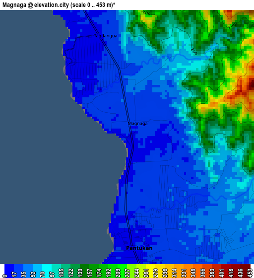
Below is the Elevation map of Magnaga, which displays elevation range with different colors. Scale of the first map is from 0 to 453 m (0 to 1486 ft) with average elevation of 73 meters (=240 ft) [note 1]
These maps also provides idea of topography and contour of this city, they are displayed at different zoom levels. More info about maps, scale and edge coordinates you can find below images.
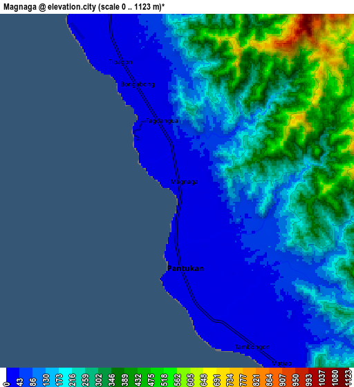
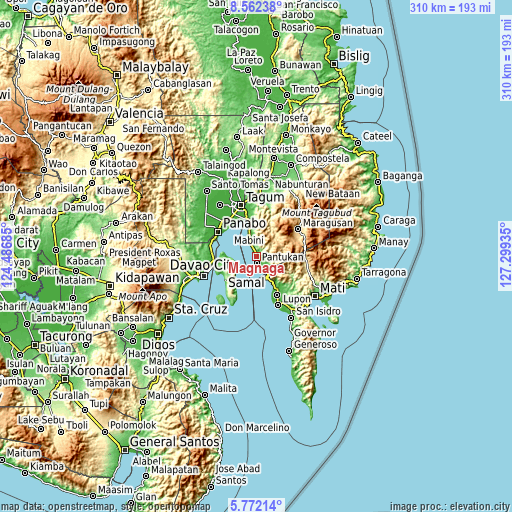
| \ | Map #1 | Map #2 | Topo.Map |
| Scale [m] | 0..453 m | 0..1123 m | × |
| Scale [ft] | 0..1486 ft | 0..3684 ft | × |
| Average | 73 m = 240 ft | 202.9 m = 666 ft | × |
| Width | 9.7 km = 6 mi | 19.39 km = 12 mi | 310.2 km = 192.7 mi |
| Height | 9.7 km = 6 mi | 19.39 km = 12 mi | 310.3 km = 192.8 mi |
| ↑Max Latitude | 7.213° | 7.256595° | 8.56238° |
| Latitude at center | 7.1694° | 7.1694° | 7.1694° |
| ↓Min Latitude | 7.125796° | 7.082188° | 5.77214° |
| ← Min Longitude | 125.849155° | 125.805209° | 124.48685° |
| Longitude center | 125.8931° | 125.8931° | 125.8931° |
| →Max Longitude | 125.937045° | 125.980991° | 127.29935° |
Nearby cities:
Cities around Magnaga sort by population:
• Cuambog elevation 12 m
16.3 km,  342°
342°
• Pandasan 24 m
13.4 km, 341°
• Tagnanan 12 m
13.9 km, 336°
• Tagdanua 16 m
4 km,  345°
345°
• Tibagon 23 m
7.8 km,  334°
334°
• Bungabon 21 m
6.3 km, 339°
• Aumbay 93 m
14.2 km,  238°
238°
• Tombongon 22 m
11.8 km,  148°
148°
• Matiao 15 m
10.7 km, 153°
• San Antonio 230 m
17.8 km,  252°
252°
• Mabini 18 m
16.4 km, 344°
• Pantukan 12 m
1 km,  135°
135°
Multilingual:
 En español:
Magnaga elevación 13 m.
 En France:
Magnaga élévation 13 m.


Sources and notes:
- [note 1] Map square and city borders are not equal. Map elevation data is calculated only from area inside that square.
- [src 1] Elevation data from geonames database provided with same terms of usage.
- [src 2] The elevation map of Magnaga is generated using elevation data from NASA's 3 arcsec (90m) resolution SRTM data.
- [src 3] Base (background) map © OpenStreetMap contributors tiles are generated by Geofabrik and OpenTopoMap.
Copyright & License:
This Magnaga Elevation Map is licensed under CC BY-SA. You may reuse any part from this page, if you give a proper credit by linking to this URL:
 More info on terms of use page.