Tombongon elevation
Tombongon (Davao, Compostela Valley), Philippines elevation is 22 meters and Tombongon elevation in feet is 72 ft above sea level [src 1]. Tombongon is a populated place (feature code) with elevation that is 66 meters (217 ft) smaller than average city elevation in Philippines.
Below is the Elevation map of Tombongon, which displays elevation range with different colors. Scale of the first map is from 0 to 844 m (0 to 2769 ft) with average elevation of 162.2 meters (=532 ft) [note 1]
These maps also provides idea of topography and contour of this city, they are displayed at different zoom levels. More info about maps, scale and edge coordinates you can find below images.
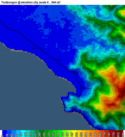
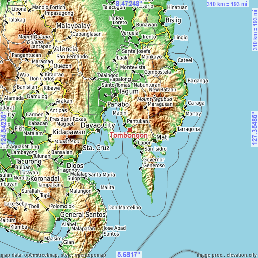
| \ | Map #1 | Topo.Map |
| Scale [m] | 0..844 m | × |
| Scale [ft] | 0..2769 ft | × |
| Average | 162.2 m = 532 ft | × |
| Width | 9.7 km = 6 mi | 310.3 km = 192.8 mi |
| Height | 9.7 km = 6 mi | 310.3 km = 192.8 mi |
| ↑Max Latitude | 7.122808° | 8.47248° |
| Latitude at center | 7.0792° | 7.0792° |
| ↓Min Latitude | 7.035588° | 5.6817° |
| ← Min Longitude | 125.904655° | 124.54235° |
| Longitude center | 125.9486° | 125.9486° |
| →Max Longitude | 125.992545° | 127.35485° |
Nearby cities:
Cities around Tombongon sort by population:
• Lupon elevation 23 m
21.2 km,  161°
161°
• Magnaga 13 m
11.8 km,  328°
328°
• Tagdanua 16 m
15.6 km, 332°
• Tibagon 23 m
19.5 km, 330°
• Bungabon 21 m
17.9 km, 332°
• Ilangay 33 m
21.6 km,  148°
148°
• Aumbay 93 m
18.4 km,  278°
278°
• Panikian 30 m
11.3 km,  132°
132°
• Matiao 15 m
1.4 km,  286°
286°
• Linao 14 m
8.4 km, 145°
• Banaybanay 24 m
15 km, 149°
• Pantukan 12 m
10.8 km, 329°
Multilingual:
 En español:
Tombongon elevación 22 m.
 En France:
Tombongon élévation 22 m.
 Auf Deutsch:
Tombongon höhe über dem Meeresspiegel ist 22 m.

Sources and notes:
- [note 1] Map square and city borders are not equal. Map elevation data is calculated only from area inside that square.
- [src 1] Elevation data from geonames database provided with same terms of usage.
- [src 2] The elevation map of Tombongon is generated using elevation data from NASA's 3 arcsec (90m) resolution SRTM data.
- [src 3] Base (background) map © OpenStreetMap contributors tiles are generated by Geofabrik and OpenTopoMap.
Copyright & License:
This Tombongon Elevation Map is licensed under CC BY-SA. You may reuse any part from this page, if you give a proper credit by linking to this URL:
 More info on terms of use page.