Majayjay elevation
Majayjay (Calabarzon, Province of Laguna), Philippines elevation is 281 meters and Majayjay elevation in feet is 922 ft above sea level [src 1]. Majayjay is a seat of a third-order administrative division (feature code) with elevation that is 193 meters (633 ft) bigger than average city elevation in Philippines.
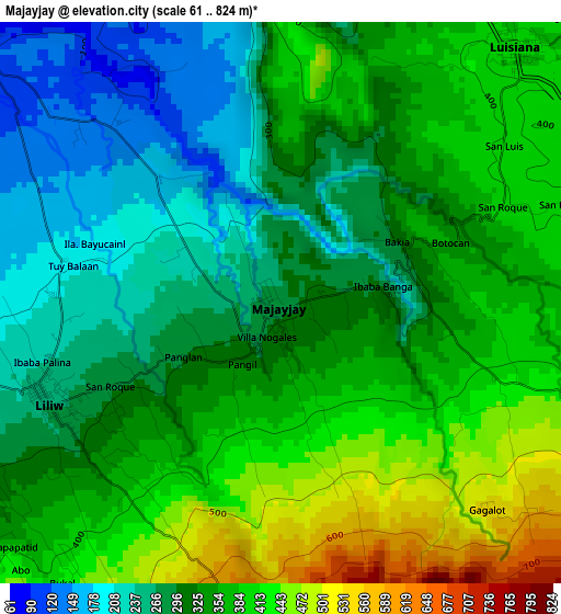
Below is the Elevation map of Majayjay, which displays elevation range with different colors. Scale of the first map is from 61 to 824 m (200 to 2703 ft) with average elevation of 336.4 meters (=1104 ft) [note 1]
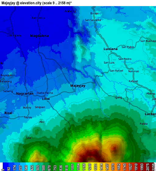
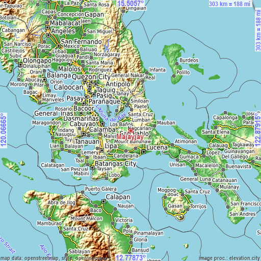
These maps also provides idea of topography and contour of this city, they are displayed at different zoom levels. More info about maps, scale and edge coordinates you can find below images.
| \ | Map #1 | Map #2 | Topo.Map |
| Scale [m] | 61..824 m | 9..2158 m | × |
| Scale [ft] | 200..2703 ft | 30..7080 ft | × |
| Average | 336.4 m = 1104 ft | 428.2 m = 1405 ft | × |
| Width | 9.48 km = 5.9 mi | 18.95 km = 11.8 mi | 303.2 km = 188.4 mi |
| Height | 9.48 km = 5.9 mi | 18.95 km = 11.8 mi | 303.2 km = 188.4 mi |
| ↑Max Latitude | 14.188909° | 14.231509° | 15.5057° |
| Latitude at center | 14.1463° | 14.1463° | 14.1463° |
| ↓Min Latitude | 14.103683° | 14.061059° | 12.77873° |
| ← Min Longitude | 121.428955° | 121.385009° | 120.06665° |
| Longitude center | 121.4729° | 121.4729° | 121.4729° |
| →Max Longitude | 121.516845° | 121.560791° | 122.87915° |
Nearby cities:
Cities around Majayjay sort by population:
• Nagcarlan elevation 201 m
6.2 km,  259°
259°
• Lilio 256 m
4.3 km,  247°
247°
• Rizal 252 m
9.5 km,  244°
244°
• Luisiana 387 m
5.9 km,  43°
43°
• Halayhayin 59 m
8.5 km,  304°
304°
• San Rafael 238 m
6.6 km, 252°
• Calumpang 49 m
9.5 km,  306°
306°
• Magdalena 67 m
7.6 km,  321°
321°
• San Antonio 384 m
6.6 km,  26°
26°
• Taytay 240 m
7.8 km, 252°
• San Diego 351 m
4.8 km,  18°
18°
• Santo Tomas 388 m
5 km, 35°
Multilingual:
 En español:
Majayjay elevación 281 m.
 En France:
Majayjay élévation 281 m.
 Auf Deutsch:
Majayjay höhe über dem Meeresspiegel ist 281 m.

Sources and notes:
- [note 1] Map square and city borders are not equal. Map elevation data is calculated only from area inside that square.
- [src 1] Elevation data from geonames database provided with same terms of usage.
- [src 2] The elevation map of Majayjay is generated using elevation data from NASA's 3 arcsec (90m) resolution SRTM data.
- [src 3] Base (background) map © OpenStreetMap contributors tiles are generated by Geofabrik and OpenTopoMap.
Copyright & License:
This Majayjay Elevation Map is licensed under CC BY-SA. You may reuse any part from this page, if you give a proper credit by linking to this URL:
 More info on terms of use page.