Makilala elevation
Makilala (Soccsksargen, Province of Cotabato), Philippines elevation is 289 meters and Makilala elevation in feet is 948 ft above sea level [src 1]. Makilala is a seat of a third-order administrative division (feature code) with elevation that is 201 meters (659 ft) bigger than average city elevation in Philippines.
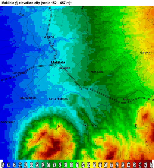
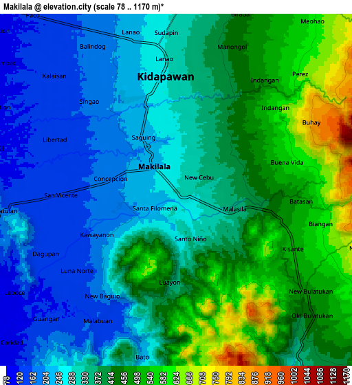
Below is the Elevation map of Makilala, which displays elevation range with different colors. Scale of the first map is from 152 to 657 m (499 to 2156 ft) with average elevation of 318.8 meters (=1046 ft) [note 1]
These maps also provides idea of topography and contour of this city, they are displayed at different zoom levels. More info about maps, scale and edge coordinates you can find below images.
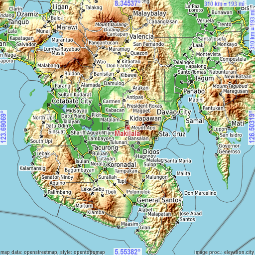
| \ | Map #1 | Map #2 | Topo.Map |
| Scale [m] | 152..657 m | 78..1170 m | × |
| Scale [ft] | 499..2156 ft | 256..3839 ft | × |
| Average | 318.8 m = 1046 ft | 361.6 m = 1186 ft | × |
| Width | 9.7 km = 6 mi | 19.4 km = 12.1 mi | 310.4 km = 192.9 mi |
| Height | 9.7 km = 6 mi | 19.4 km = 12.1 mi | 310.4 km = 192.9 mi |
| ↑Max Latitude | 6.99529° | 7.038906° | 8.34537° |
| Latitude at center | 6.95167° | 6.95167° | 6.95167° |
| ↓Min Latitude | 6.908046° | 6.864417° | 5.55382° |
| ← Min Longitude | 125.052995° | 125.009049° | 123.69069° |
| Longitude center | 125.09694° | 125.09694° | 125.09694° |
| →Max Longitude | 125.140885° | 125.184831° | 126.50319° |
Nearby cities:
Cities around Makilala sort by population:
• Kidapawan elevation 275 m
6.4 km,  352°
352°
• Amas 107 m
17.1 km,  313°
313°
• Malasila 364 m
3.7 km,  103°
103°
• Magpet 285 m
16.6 km,  7°
7°
• Saguing 219 m
3.8 km,  326°
326°
• Kisante 518 m
7.2 km,  116°
116°
• Bulatukan 476 m
8.9 km,  127°
127°
• Dolo 177 m
18.9 km,  146°
146°
• Labu-o 133 m
18.9 km,  342°
342°
• New Cebu 117 m
17.4 km, 336°
• Kalaisan 157 m
8.7 km,  318°
318°
• Batasan 164 m
10.5 km, 330°
Multilingual:
 En español:
Makilala elevación 289 m.
 En France:
Makilala élévation 289 m.
 Auf Deutsch:
Makilala höhe über dem Meeresspiegel ist 289 m.

Sources and notes:
- [note 1] Map square and city borders are not equal. Map elevation data is calculated only from area inside that square.
- [src 1] Elevation data from geonames database provided with same terms of usage.
- [src 2] The elevation map of Makilala is generated using elevation data from NASA's 3 arcsec (90m) resolution SRTM data.
- [src 3] Base (background) map © OpenStreetMap contributors tiles are generated by Geofabrik and OpenTopoMap.
Copyright & License:
This Makilala Elevation Map is licensed under CC BY-SA. You may reuse any part from this page, if you give a proper credit by linking to this URL:
 More info on terms of use page.