Malabog elevation
Malabog (Bicol, Province of Albay), Philippines elevation is 117 meters and Malabog elevation in feet is 384 ft above sea level [src 1]. Malabog is a populated place (feature code) with elevation that is 29 meters (95 ft) bigger than average city elevation in Philippines.
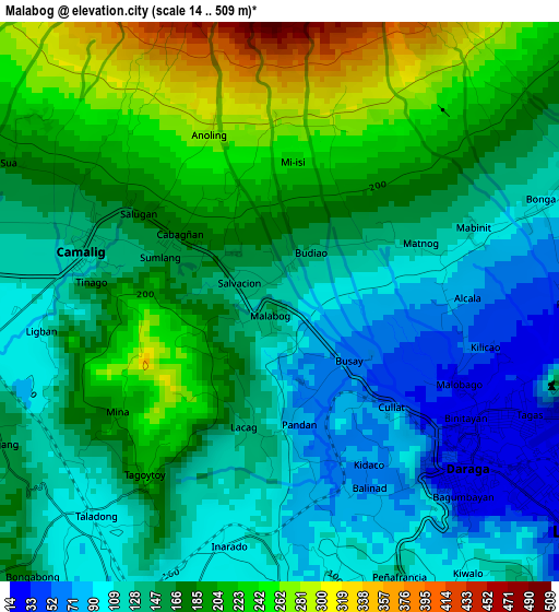
Below is the Elevation map of Malabog, which displays elevation range with different colors. Scale of the first map is from 14 to 509 m (46 to 1670 ft) with average elevation of 162.4 meters (=533 ft) [note 1]
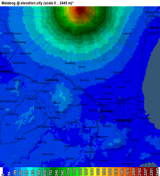
These maps also provides idea of topography and contour of this city, they are displayed at different zoom levels. More info about maps, scale and edge coordinates you can find below images.
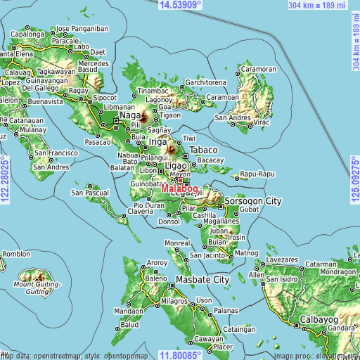
| \ | Map #1 | Map #2 | Topo.Map |
| Scale [m] | 14..509 m | 0..2445 m | × |
| Scale [ft] | 46..1670 ft | 0..8022 ft | × |
| Average | 162.4 m = 533 ft | 222 m = 728 ft | × |
| Width | 9.52 km = 5.9 mi | 19.03 km = 11.8 mi | 304.5 km = 189.2 mi |
| Height | 9.52 km = 5.9 mi | 19.03 km = 11.8 mi | 304.5 km = 189.2 mi |
| ↑Max Latitude | 13.216585° | 13.259363° | 14.53909° |
| Latitude at center | 13.1738° | 13.1738° | 13.1738° |
| ↓Min Latitude | 13.131007° | 13.088207° | 11.80085° |
| ← Min Longitude | 123.642555° | 123.598609° | 122.28025° |
| Longitude center | 123.6865° | 123.6865° | 123.6865° |
| →Max Longitude | 123.730445° | 123.774391° | 125.09275° |
Nearby cities:
Cities around Malabog sort by population:
• Tagas elevation 55 m
3.4 km,  103°
103°
• Sagpon 15 m
5.7 km,  117°
117°
• Daraga 27 m
4 km,  135°
135°
• Baligang 150 m
5.2 km,  244°
244°
• Tinago 130 m
4.1 km,  285°
285°
• Pawa 49 m
4.7 km,  85°
85°
• Cotmon 93 m
6.7 km,  201°
201°
• Anuling 370 m
4.1 km,  344°
344°
• Cabognon 174 m
1.4 km,  316°
316°
• Lacag 146 m
2.1 km, 195°
• Bariw 14 m
6.8 km,  131°
131°
• Camalig 131 m
3.6 km,  284°
284°
Multilingual:
 En español:
Malabog elevación 117 m.
 En France:
Malabog élévation 117 m.


Sources and notes:
- [note 1] Map square and city borders are not equal. Map elevation data is calculated only from area inside that square.
- [src 1] Elevation data from geonames database provided with same terms of usage.
- [src 2] The elevation map of Malabog is generated using elevation data from NASA's 3 arcsec (90m) resolution SRTM data.
- [src 3] Base (background) map © OpenStreetMap contributors tiles are generated by Geofabrik and OpenTopoMap.
Copyright & License:
This Malabog Elevation Map is licensed under CC BY-SA. You may reuse any part from this page, if you give a proper credit by linking to this URL:
 More info on terms of use page.