Sagpon elevation
Sagpon (Bicol, Province of Albay), Philippines elevation is 15 meters and Sagpon elevation in feet is 49 ft above sea level [src 1]. Sagpon is a populated place (feature code) with elevation that is 73 meters (240 ft) smaller than average city elevation in Philippines.
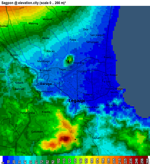
Below is the Elevation map of Sagpon, which displays elevation range with different colors. Scale of the first map is from 0 to 266 m (0 to 873 ft) with average elevation of 67.4 meters (=221 ft) [note 1]
These maps also provides idea of topography and contour of this city, they are displayed at different zoom levels. More info about maps, scale and edge coordinates you can find below images.
| \ | Map #1 | Map #2 | Topo.Map |
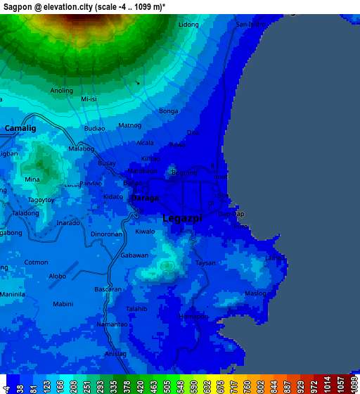
| Scale [m] | 0..266 m | -4..1099 m | × |
| Scale [ft] | 0..873 ft | -13..3606 ft | × |
| Average | 67.4 m = 221 ft | 140.1 m = 460 ft | × |
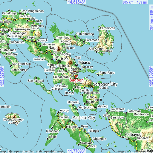
| Width | 9.52 km = 5.9 mi | 19.03 km = 11.8 mi | 304.5 km = 189.2 mi |
| Height | 9.52 km = 5.9 mi | 19.03 km = 11.8 mi | 304.5 km = 189.2 mi |
| ↑Max Latitude | 13.192789° | 13.235571° | 14.51543° |
| Latitude at center | 13.15° | 13.15° | 13.15° |
| ↓Min Latitude | 13.107203° | 13.064399° | 11.77693° |
| ← Min Longitude | 123.689385° | 123.645439° | 122.32708° |
| Longitude center | 123.73333° | 123.73333° | 123.73333° |
| →Max Longitude | 123.777275° | 123.821221° | 125.13958° |
Nearby cities:
Cities around Sagpon sort by population:
• Legaspi elevation 9 m
1.3 km,  140°
140°
• Tagas 55 m
2.6 km,  315°
315°
• Bigaa 14 m
6 km,  24°
24°
• Daraga 27 m
2.3 km,  265°
265°
• San Roque 6 m
2.3 km,  76°
76°
• Malabog 117 m
5.7 km,  297°
297°
• Maslog 79 m
6.5 km, 140°
• Pawa 49 m
3.1 km,  353°
353°
• Bascaron 124 m
6.4 km,  214°
214°
• Barayong 85 m
5.8 km,  197°
197°
• Lacag 146 m
5.7 km,  275°
275°
• Bariw 14 m
1.9 km,  180°
180°
Multilingual:
 En español:
Sagpon elevación 15 m.
 En France:
Sagpon élévation 15 m.


Sources and notes:
- [note 1] Map square and city borders are not equal. Map elevation data is calculated only from area inside that square.
- [src 1] Elevation data from geonames database provided with same terms of usage.
- [src 2] The elevation map of Sagpon is generated using elevation data from NASA's 3 arcsec (90m) resolution SRTM data.
- [src 3] Base (background) map © OpenStreetMap contributors tiles are generated by Geofabrik and OpenTopoMap.
Copyright & License:
This Sagpon Elevation Map is licensed under CC BY-SA. You may reuse any part from this page, if you give a proper credit by linking to this URL:
 More info on terms of use page.