Maulawin elevation
Maulawin (Calabarzon, Province of Laguna), Philippines elevation is 9 meters and Maulawin elevation in feet is 30 ft above sea level [src 1]. Maulawin is a populated place (feature code) with elevation that is 79 meters (259 ft) smaller than average city elevation in Philippines.
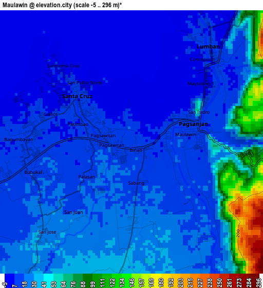
Below is the Elevation map of Maulawin, which displays elevation range with different colors. Scale of the first map is from -5 to 296 m (-16 to 971 ft) with average elevation of 27 meters (=89 ft) [note 1]
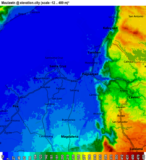
These maps also provides idea of topography and contour of this city, they are displayed at different zoom levels. More info about maps, scale and edge coordinates you can find below images.
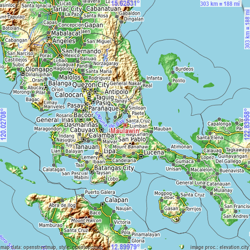
| \ | Map #1 | Map #2 | Topo.Map |
| Scale [m] | -5..296 m | -12..489 m | × |
| Scale [ft] | -16..971 ft | -39..1604 ft | × |
| Average | 27 m = 89 ft | 91.1 m = 299 ft | × |
| Width | 9.47 km = 5.9 mi | 18.94 km = 11.8 mi | 303 km = 188.3 mi |
| Height | 9.47 km = 5.9 mi | 18.94 km = 11.8 mi | 303.1 km = 188.3 mi |
| ↑Max Latitude | 14.309256° | 14.351834° | 15.62531° |
| Latitude at center | 14.26667° | 14.26667° | 14.26667° |
| ↓Min Latitude | 14.224076° | 14.181474° | 12.89979° |
| ← Min Longitude | 121.389385° | 121.345439° | 120.02708° |
| Longitude center | 121.43333° | 121.43333° | 121.43333° |
| →Max Longitude | 121.477275° | 121.521221° | 122.83958° |
Nearby cities:
Cities around Maulawin sort by population:
• Santa Cruz elevation 9 m
2.5 km,  311°
311°
• Pila 14 m
8.3 km,  242°
242°
• Lumbang 9 m
4.4 km,  39°
39°
• Cavinti 219 m
8.4 km,  106°
106°
• Cabanbanan 26 m
2.9 km,  178°
178°
• Pagsanjan 11 m
2.5 km,  72°
72°
• Halayhayin 59 m
9.1 km,  197°
197°
• Calumpang 49 m
8.5 km, 203°
• San Isidro 44 m
7.5 km,  210°
210°
• Magdalena 67 m
7.4 km, 183°
• Wawa 7 m
4.8 km, 35°
• Cigaras 35 m
4.5 km, 184°
Multilingual:
 En español:
Maulawin elevación 9 m.
 En France:
Maulawin élévation 9 m.


Sources and notes:
- [note 1] Map square and city borders are not equal. Map elevation data is calculated only from area inside that square.
- [src 1] Elevation data from geonames database provided with same terms of usage.
- [src 2] The elevation map of Maulawin is generated using elevation data from NASA's 3 arcsec (90m) resolution SRTM data.
- [src 3] Base (background) map © OpenStreetMap contributors tiles are generated by Geofabrik and OpenTopoMap.
Copyright & License:
This Maulawin Elevation Map is licensed under CC BY-SA. You may reuse any part from this page, if you give a proper credit by linking to this URL:
 More info on terms of use page.