Monkayo elevation
Monkayo (Davao, Compostela Valley), Philippines elevation is 61 meters and Monkayo elevation in feet is 200 ft above sea level [src 1]. Monkayo is a seat of a third-order administrative division (feature code) with elevation that is 27 meters (89 ft) smaller than average city elevation in Philippines.
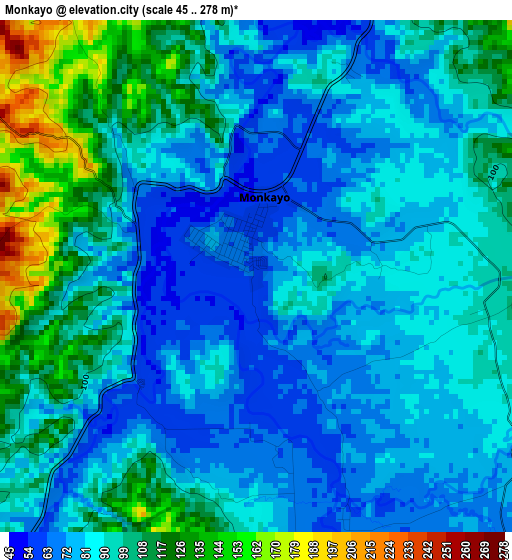
Below is the Elevation map of Monkayo, which displays elevation range with different colors. Scale of the first map is from 45 to 278 m (148 to 912 ft) with average elevation of 91 meters (=299 ft) [note 1]
These maps also provides idea of topography and contour of this city, they are displayed at different zoom levels. More info about maps, scale and edge coordinates you can find below images.
| \ | Map #1 | Map #2 | Topo.Map |
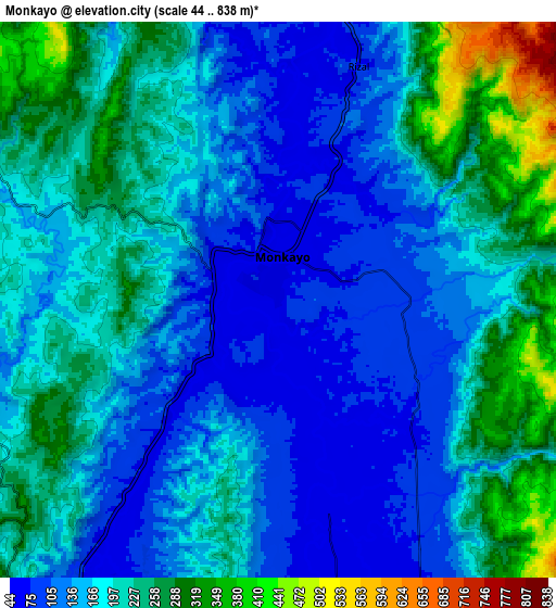
| Scale [m] | 45..278 m | 44..838 m | × |
| Scale [ft] | 148..912 ft | 144..2749 ft | × |
| Average | 91 m = 299 ft | 184.4 m = 605 ft | × |
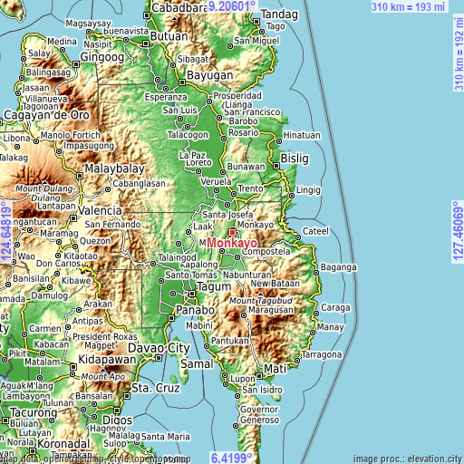
| Width | 9.68 km = 6 mi | 19.36 km = 12 mi | 309.8 km = 192.5 mi |
| Height | 9.68 km = 6 mi | 19.36 km = 12 mi | 309.8 km = 192.5 mi |
| ↑Max Latitude | 7.858815° | 7.902345° | 9.20601° |
| Latitude at center | 7.81528° | 7.81528° | 7.81528° |
| ↓Min Latitude | 7.771741° | 7.728197° | 6.4199° |
| ← Min Longitude | 126.010495° | 125.966549° | 124.64819° |
| Longitude center | 126.05444° | 126.05444° | 126.05444° |
| →Max Longitude | 126.098385° | 126.142331° | 127.46069° |
Nearby cities:
Cities around Monkayo sort by population:
• Compostela elevation 74 m
16.3 km,  166°
166°
• Cabinuangan 67 m
14.9 km,  189°
189°
• Montevista 73 m
15.4 km,  208°
208°
• Salvacion 69 m
21.9 km,  20°
20°
• Pasian 50 m
12.6 km,  6°
6°
• Santa Josefa 36 m
19.7 km,  352°
352°
• Gabi 89 m
21.9 km, 169°
• Baylo 79 m
4.4 km,  1°
1°
• Babag 68 m
9.3 km, 168°
• Linoan 90 m
22.8 km,  202°
202°
• Tapia 72 m
8.3 km, 214°
• Cuevas 50 m
23.1 km, 10°
Multilingual:
 En español:
Monkayo elevación 61 m.
 En France:
Monkayo élévation 61 m.


Sources and notes:
- [note 1] Map square and city borders are not equal. Map elevation data is calculated only from area inside that square.
- [src 1] Elevation data from geonames database provided with same terms of usage.
- [src 2] The elevation map of Monkayo is generated using elevation data from NASA's 3 arcsec (90m) resolution SRTM data.
- [src 3] Base (background) map © OpenStreetMap contributors tiles are generated by Geofabrik and OpenTopoMap.
Copyright & License:
This Monkayo Elevation Map is licensed under CC BY-SA. You may reuse any part from this page, if you give a proper credit by linking to this URL:
 More info on terms of use page.