Payocpoc Sur elevation
Payocpoc Sur (Ilocos, Province of La Union), Philippines elevation is 14 meters and Payocpoc Sur elevation in feet is 46 ft above sea level [src 1]. Payocpoc Sur is a populated place (feature code) with elevation that is 74 meters (243 ft) smaller than average city elevation in Philippines.
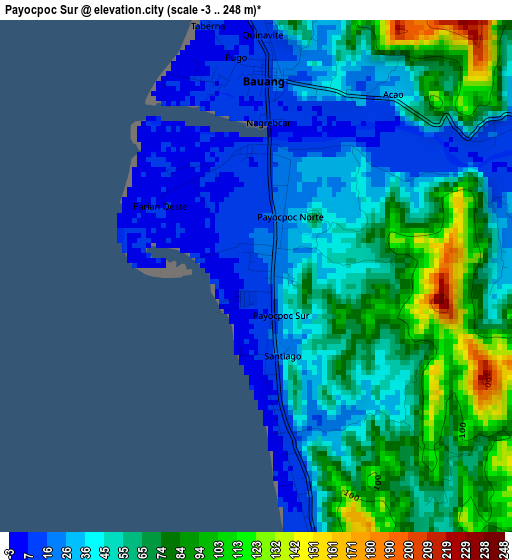
Below is the Elevation map of Payocpoc Sur, which displays elevation range with different colors. Scale of the first map is from -3 to 248 m (-10 to 814 ft) with average elevation of 53.6 meters (=176 ft) [note 1]
These maps also provides idea of topography and contour of this city, they are displayed at different zoom levels. More info about maps, scale and edge coordinates you can find below images.
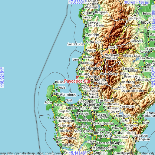
| \ | Map #1 | Map #2 | Topo.Map |
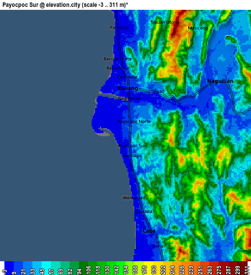
| Scale [m] | -3..248 m | -3..311 m | × |
| Scale [ft] | -10..814 ft | -10..1020 ft | × |
| Average | 53.6 m = 176 ft | 69.8 m = 229 ft | × |
| Width | 9.37 km = 5.8 mi | 18.74 km = 11.6 mi | 299.8 km = 186.3 mi |
| Height | 9.37 km = 5.8 mi | 18.74 km = 11.6 mi | 299.8 km = 186.3 mi |
| ↑Max Latitude | 16.536572° | 16.578695° | 17.83801° |
| Latitude at center | 16.49444° | 16.49444° | 16.49444° |
| ↓Min Latitude | 16.452299° | 16.410148° | 15.14148° |
| ← Min Longitude | 120.284115° | 120.240169° | 118.92181° |
| Longitude center | 120.32806° | 120.32806° | 120.32806° |
| →Max Longitude | 120.372005° | 120.415951° | 121.73431° |
Nearby cities:
Cities around Payocpoc Sur sort by population:
• San Fernando elevation 9 m
13.6 km,  354°
354°
• Aringay 16 m
11.5 km,  165°
165°
• Bauang 13 m
4.1 km,  7°
7°
• Paringao 7 m
8.6 km,  357°
357°
• Caba 14 m
7.2 km, 165°
• Acao 41 m
6.2 km,  56°
56°
• San Eugenio 27 m
15.3 km, 168°
• Leones East 33 m
16.1 km,  154°
154°
• Halog West 23 m
16.9 km, 146°
• Nangalisan 183 m
17.3 km,  112°
112°
• Burgos 441 m
14.6 km,  79°
79°
• Naguilian 20 m
8.5 km, 59°
Multilingual:
 En español:
Payocpoc Sur elevación 14 m.
 En France:
Payocpoc Sur élévation 14 m.
 Auf Deutsch:
Payocpoc Sur höhe über dem Meeresspiegel ist 14 m.

Sources and notes:
- [note 1] Map square and city borders are not equal. Map elevation data is calculated only from area inside that square.
- [src 1] Elevation data from geonames database provided with same terms of usage.
- [src 2] The elevation map of Payocpoc Sur is generated using elevation data from NASA's 3 arcsec (90m) resolution SRTM data.
- [src 3] Base (background) map © OpenStreetMap contributors tiles are generated by Geofabrik and OpenTopoMap.
Copyright & License:
This Payocpoc Sur Elevation Map is licensed under CC BY-SA. You may reuse any part from this page, if you give a proper credit by linking to this URL:
 More info on terms of use page.