Pili elevation
Pili (Bicol, Province of Camarines Sur), Philippines elevation is 324 meters and Pili elevation in feet is 1063 ft above sea level [src 1]. Pili is a seat of a third-order administrative division (feature code) with elevation that is 236 meters (774 ft) bigger than average city elevation in Philippines.
Below is the Elevation map of Pili, which displays elevation range with different colors. Scale of the first map is from 75 to 1311 m (246 to 4301 ft) with average elevation of 351.7 meters (=1154 ft) [note 1]
These maps also provides idea of topography and contour of this city, they are displayed at different zoom levels. More info about maps, scale and edge coordinates you can find below images.

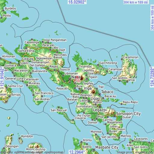
| \ | Map #1 | Topo.Map |
| Scale [m] | 75..1311 m | × |
| Scale [ft] | 246..4301 ft | × |
| Average | 351.7 m = 1154 ft | × |
| Width | 9.5 km = 5.9 mi | 303.8 km = 188.8 mi |
| Height | 9.5 km = 5.9 mi | 303.9 km = 188.8 mi |
| ↑Max Latitude | 13.709367° | 15.02902° |
| Latitude at center | 13.66667° | 13.66667° |
| ↓Min Latitude | 13.623965° | 12.2964° |
| ← Min Longitude | 123.272725° | 121.91042° |
| Longitude center | 123.31667° | 123.31667° |
| →Max Longitude | 123.360615° | 124.72292° |
Nearby cities:
Cities around Pili sort by population:
• Calabanga elevation 5 m
12.5 km,  290°
290°
• Bombon 4 m
12 km,  281°
281°
• Palestina 45 m
9.5 km,  230°
230°
• Cadlan 42 m
10.1 km,  219°
219°
• Manquiring 30 m
9.1 km,  325°
325°
• Paulba 34 m
8.9 km,  305°
305°
• Binanwanaan 197 m
4.1 km, 334°
• Bagacay 6 m
12.4 km,  353°
353°
• Gatbo 145 m
11.7 km,  142°
142°
• Curry 84 m
7.6 km,  193°
193°
• San Lucas 5 m
13 km, 289°
• San Agustin 38 m
11.8 km,  208°
208°
Multilingual:
 En español:
Pili elevación 324 m.
 En France:
Pili élévation 324 m.


Sources and notes:
- [note 1] Map square and city borders are not equal. Map elevation data is calculated only from area inside that square.
- [src 1] Elevation data from geonames database provided with same terms of usage.
- [src 2] The elevation map of Pili is generated using elevation data from NASA's 3 arcsec (90m) resolution SRTM data.
- [src 3] Base (background) map © OpenStreetMap contributors tiles are generated by Geofabrik and OpenTopoMap.
Copyright & License:
This Pili Elevation Map is licensed under CC BY-SA. You may reuse any part from this page, if you give a proper credit by linking to this URL:
 More info on terms of use page.