Cadlan elevation
Cadlan (Bicol, Province of Camarines Sur), Philippines elevation is 42 meters and Cadlan elevation in feet is 138 ft above sea level [src 1]. Cadlan is a populated place (feature code) with elevation that is 46 meters (151 ft) smaller than average city elevation in Philippines.
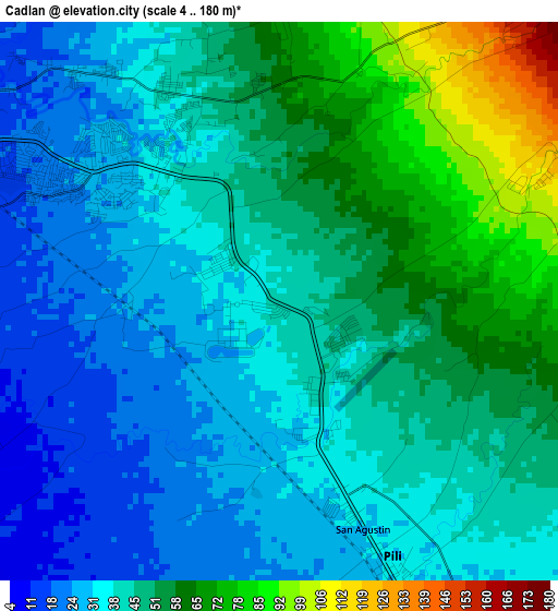
Below is the Elevation map of Cadlan, which displays elevation range with different colors. Scale of the first map is from 4 to 180 m (13 to 591 ft) with average elevation of 44.7 meters (=147 ft) [note 1]
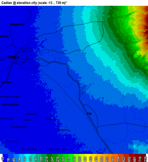
These maps also provides idea of topography and contour of this city, they are displayed at different zoom levels. More info about maps, scale and edge coordinates you can find below images.
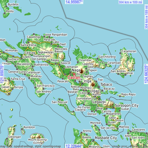
| \ | Map #1 | Map #2 | Topo.Map |
| Scale [m] | 4..180 m | -13..739 m | × |
| Scale [ft] | 13..591 ft | -43..2425 ft | × |
| Average | 44.7 m = 147 ft | 69.9 m = 229 ft | × |
| Width | 9.5 km = 5.9 mi | 19 km = 11.8 mi | 303.9 km = 188.8 mi |
| Height | 9.5 km = 5.9 mi | 19 km = 11.8 mi | 304 km = 188.9 mi |
| ↑Max Latitude | 13.63981° | 13.682512° | 14.95987° |
| Latitude at center | 13.5971° | 13.5971° | 13.5971° |
| ↓Min Latitude | 13.554382° | 13.511657° | 12.22644° |
| ← Min Longitude | 123.213055° | 123.169109° | 121.85075° |
| Longitude center | 123.257° | 123.257° | 123.257° |
| →Max Longitude | 123.300945° | 123.344891° | 124.66325° |
Nearby cities:
Cities around Cadlan sort by population:
• Naga elevation 4 m
8.5 km,  286°
286°
• Milaor 5 m
8.6 km,  269°
269°
• Minalabac 5 m
8.5 km,  248°
248°
• Palestina 45 m
1.8 km,  331°
331°
• Himaao 24 m
7.5 km,  141°
141°
• Ayugan 33 m
8.9 km,  128°
128°
• Tariric 14 m
4.6 km,  232°
232°
• Curry 84 m
4.7 km,  86°
86°
• Pawili 19 m
9.4 km,  162°
162°
• San Agustin 38 m
2.7 km, 163°
• Capucnasan 18 m
4.4 km, 274°
• Causip 19 m
9.5 km, 162°
Multilingual:
 En español:
Cadlan elevación 42 m.
 En France:
Cadlan élévation 42 m.


Sources and notes:
- [note 1] Map square and city borders are not equal. Map elevation data is calculated only from area inside that square.
- [src 1] Elevation data from geonames database provided with same terms of usage.
- [src 2] The elevation map of Cadlan is generated using elevation data from NASA's 3 arcsec (90m) resolution SRTM data.
- [src 3] Base (background) map © OpenStreetMap contributors tiles are generated by Geofabrik and OpenTopoMap.
Copyright & License:
This Cadlan Elevation Map is licensed under CC BY-SA. You may reuse any part from this page, if you give a proper credit by linking to this URL:
 More info on terms of use page.