Pio Duran elevation
Pio Duran (Bicol, Province of Albay), Philippines elevation is 7 meters and Pio Duran elevation in feet is 23 ft above sea level [src 1]. Pio Duran is a seat of a third-order administrative division (feature code) with elevation that is 81 meters (266 ft) smaller than average city elevation in Philippines.
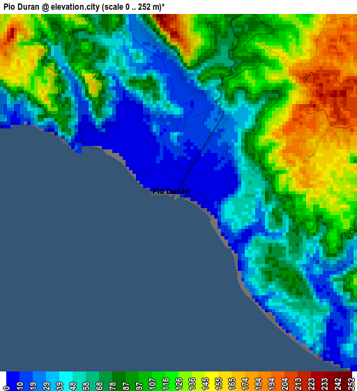
Below is the Elevation map of Pio Duran, which displays elevation range with different colors. Scale of the first map is from 0 to 252 m (0 to 827 ft) with average elevation of 82.4 meters (=270 ft) [note 1]
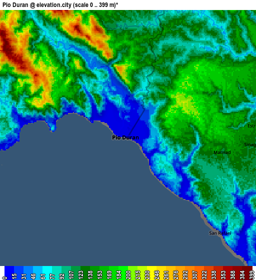
These maps also provides idea of topography and contour of this city, they are displayed at different zoom levels. More info about maps, scale and edge coordinates you can find below images.
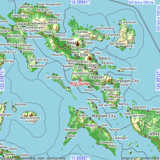
| \ | Map #1 | Map #2 | Topo.Map |
| Scale [m] | 0..252 m | 0..399 m | × |
| Scale [ft] | 0..827 ft | 0..1309 ft | × |
| Average | 82.4 m = 270 ft | 123.4 m = 405 ft | × |
| Width | 9.52 km = 5.9 mi | 19.04 km = 11.8 mi | 304.6 km = 189.3 mi |
| Height | 9.52 km = 5.9 mi | 19.04 km = 11.8 mi | 304.7 km = 189.3 mi |
| ↑Max Latitude | 13.07209° | 13.114893° | 14.39541° |
| Latitude at center | 13.02928° | 13.02928° | 13.02928° |
| ↓Min Latitude | 12.986462° | 12.943637° | 11.65557° |
| ← Min Longitude | 123.401015° | 123.357069° | 122.03871° |
| Longitude center | 123.44496° | 123.44496° | 123.44496° |
| →Max Longitude | 123.488905° | 123.532851° | 124.85121° |
Nearby cities:
Cities around Pio Duran sort by population:
• Jovellar elevation 33 m
17.4 km,  75°
75°
• Mauraro 159 m
21.1 km,  50°
50°
• Maonon 8 m
8.1 km,  275°
275°
• Salvacion 103 m
19.1 km, 77°
• Cagmanaba 1 m
16.3 km, 280°
• Badian 9 m
14.9 km,  271°
271°
• Basicao Coastal 8 m
4.8 km,  292°
292°
• Binodegahan 79 m
3.8 km,  21°
21°
• Paulba 59 m
16.7 km,  6°
6°
• Malidong 24 m
2.4 km,  138°
138°
• Dangcalan 7 m
19.6 km,  129°
129°
• Apud 9 m
20.6 km,  306°
306°
Multilingual:
 En español:
Pio Duran elevación 7 m.
 En France:
Pio Duran élévation 7 m.


Sources and notes:
- [note 1] Map square and city borders are not equal. Map elevation data is calculated only from area inside that square.
- [src 1] Elevation data from geonames database provided with same terms of usage.
- [src 2] The elevation map of Pio Duran is generated using elevation data from NASA's 3 arcsec (90m) resolution SRTM data.
- [src 3] Base (background) map © OpenStreetMap contributors tiles are generated by Geofabrik and OpenTopoMap.
Copyright & License:
This Pio Duran Elevation Map is licensed under CC BY-SA. You may reuse any part from this page, if you give a proper credit by linking to this URL:
 More info on terms of use page.