Potia elevation
Potia (Cordillera, Province of Ifugao), Philippines elevation is 171 meters and Potia elevation in feet is 561 ft above sea level [src 1]. Potia is a seat of a third-order administrative division (feature code) with elevation that is 83 meters (272 ft) bigger than average city elevation in Philippines.
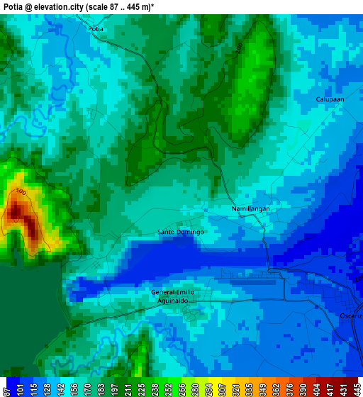
Below is the Elevation map of Potia, which displays elevation range with different colors. Scale of the first map is from 87 to 445 m (285 to 1460 ft) with average elevation of 163 meters (=535 ft) [note 1]
These maps also provides idea of topography and contour of this city, they are displayed at different zoom levels. More info about maps, scale and edge coordinates you can find below images.
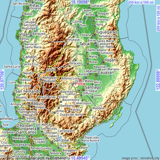
| \ | Map #1 | Topo.Map |
| Scale [m] | 87..445 m | × |
| Scale [ft] | 285..1460 ft | × |
| Average | 163 m = 535 ft | × |
| Width | 9.35 km = 5.8 mi | 299.3 km = 186 mi |
| Height | 9.35 km = 5.8 mi | 299.3 km = 186 mi |
| ↑Max Latitude | 16.892054° | 18.19098° |
| Latitude at center | 16.85° | 16.85° |
| ↓Min Latitude | 16.807937° | 15.49945° |
| ← Min Longitude | 121.439385° | 120.07708° |
| Longitude center | 121.48333° | 121.48333° |
| →Max Longitude | 121.527275° | 122.88958° |
Nearby cities:
Cities around Potia sort by population:
• Santiago elevation 86 m
19.3 km,  158°
158°
• Ramon 109 m
9.2 km,  143°
143°
• San Mateo 82 m
11.6 km,  72°
72°
• Diadi 276 m
19.1 km,  223°
223°
• Salinungan Proper 80 m
14.1 km,  81°
81°
• Sinamar 82 m
10.5 km,  57°
57°
• Cordon 119 m
19.6 km,  185°
185°
• Cabulay 106 m
11.7 km,  172°
172°
• Rizal 92 m
16.5 km,  152°
152°
• Bagong Tanza 70 m
20.1 km,  42°
42°
• Diamantina 72 m
17 km, 63°
• San Isidro 78 m
19.2 km,  132°
132°
Multilingual:
 En español:
Potia elevación 171 m.
 En France:
Potia élévation 171 m.


Sources and notes:
- [note 1] Map square and city borders are not equal. Map elevation data is calculated only from area inside that square.
- [src 1] Elevation data from geonames database provided with same terms of usage.
- [src 2] The elevation map of Potia is generated using elevation data from NASA's 3 arcsec (90m) resolution SRTM data.
- [src 3] Base (background) map © OpenStreetMap contributors tiles are generated by Geofabrik and OpenTopoMap.
Copyright & License:
This Potia Elevation Map is licensed under CC BY-SA. You may reuse any part from this page, if you give a proper credit by linking to this URL:
 More info on terms of use page.