Puting Kahoy elevation
Puting Kahoy (Calabarzon, Province of Cavite), Philippines elevation is 234 meters and Puting Kahoy elevation in feet is 768 ft above sea level [src 1]. Puting Kahoy is a populated place (feature code) with elevation that is 146 meters (479 ft) bigger than average city elevation in Philippines.
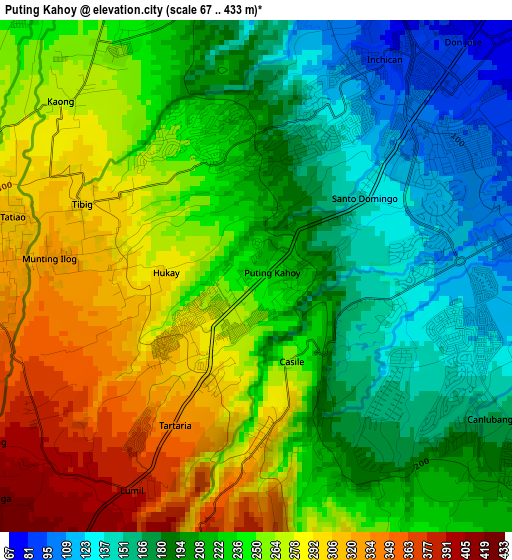
Below is the Elevation map of Puting Kahoy, which displays elevation range with different colors. Scale of the first map is from 67 to 433 m (220 to 1421 ft) with average elevation of 230.7 meters (=757 ft) [note 1]
These maps also provides idea of topography and contour of this city, they are displayed at different zoom levels. More info about maps, scale and edge coordinates you can find below images.
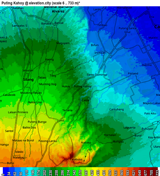
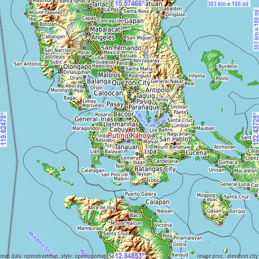
| \ | Map #1 | Map #2 | Topo.Map |
| Scale [m] | 67..433 m | 6..733 m | × |
| Scale [ft] | 220..1421 ft | 20..2405 ft | × |
| Average | 230.7 m = 757 ft | 230.9 m = 758 ft | × |
| Width | 9.47 km = 5.9 mi | 18.95 km = 11.8 mi | 303.1 km = 188.3 mi |
| Height | 9.47 km = 5.9 mi | 18.95 km = 11.8 mi | 303.1 km = 188.3 mi |
| ↑Max Latitude | 14.258296° | 14.300883° | 15.57466° |
| Latitude at center | 14.2157° | 14.2157° | 14.2157° |
| ↓Min Latitude | 14.173096° | 14.130485° | 12.84853° |
| ← Min Longitude | 120.987055° | 120.943109° | 119.62475° |
| Longitude center | 121.031° | 121.031° | 121.031° |
| →Max Longitude | 121.074945° | 121.118891° | 122.43725° |
Nearby cities:
Cities around Puting Kahoy sort by population:
• Cabuyao elevation 15 m
12.1 km,  58°
58°
• Silang 332 m
6.4 km,  269°
269°
• Pulong Santa Cruz 52 m
8.1 km,  37°
37°
• Carmona 28 m
11.2 km,  14°
14°
• Bulihan 204 m
8 km,  330°
330°
• Balite Segundo 396 m
7.1 km,  239°
239°
• Malabag 493 m
9.8 km,  226°
226°
• Maguyam 233 m
5.9 km, 331°
• Biga 237 m
7.9 km,  306°
306°
• Prinza 76 m
11.6 km,  100°
100°
• Lumil 381 m
4.4 km,  210°
210°
• Tranca 194 m
11.2 km,  165°
165°
Multilingual:
 En español:
Puting Kahoy elevación 234 m.
 En France:
Puting Kahoy élévation 234 m.
 Auf Deutsch:
Puting Kahoy höhe über dem Meeresspiegel ist 234 m.

Sources and notes:
- [note 1] Map square and city borders are not equal. Map elevation data is calculated only from area inside that square.
- [src 1] Elevation data from geonames database provided with same terms of usage.
- [src 2] The elevation map of Puting Kahoy is generated using elevation data from NASA's 3 arcsec (90m) resolution SRTM data.
- [src 3] Base (background) map © OpenStreetMap contributors tiles are generated by Geofabrik and OpenTopoMap.
Copyright & License:
This Puting Kahoy Elevation Map is licensed under CC BY-SA. You may reuse any part from this page, if you give a proper credit by linking to this URL:
 More info on terms of use page.