San Narciso elevation
San Narciso (Calabarzon, Province of Quezon), Philippines elevation is 21 meters and San Narciso elevation in feet is 69 ft above sea level [src 1]. San Narciso is a populated place (feature code) with elevation that is 67 meters (220 ft) smaller than average city elevation in Philippines.
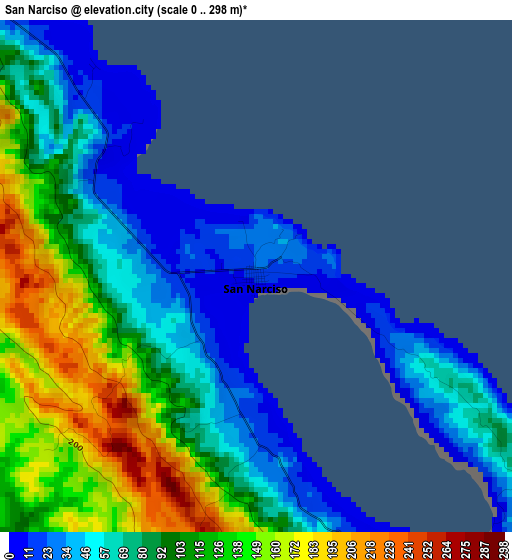
Below is the Elevation map of San Narciso, which displays elevation range with different colors. Scale of the first map is from 0 to 298 m (0 to 978 ft) with average elevation of 91.4 meters (=300 ft) [note 1]
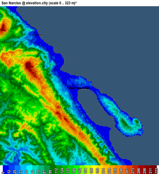
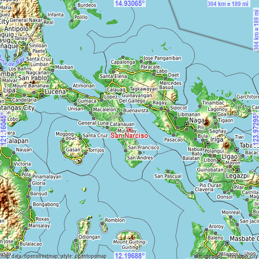
These maps also provides idea of topography and contour of this city, they are displayed at different zoom levels. More info about maps, scale and edge coordinates you can find below images.
| \ | Map #1 | Map #2 | Topo.Map |
| Scale [m] | 0..298 m | 0..323 m | × |
| Scale [ft] | 0..978 ft | 0..1060 ft | × |
| Average | 91.4 m = 300 ft | 110.5 m = 363 ft | × |
| Width | 9.5 km = 5.9 mi | 19 km = 11.8 mi | 304 km = 188.9 mi |
| Height | 9.5 km = 5.9 mi | 19 km = 11.8 mi | 304 km = 188.9 mi |
| ↑Max Latitude | 13.610415° | 13.653122° | 14.93065° |
| Latitude at center | 13.5677° | 13.5677° | 13.5677° |
| ↓Min Latitude | 13.524977° | 13.482247° | 12.19688° |
| ← Min Longitude | 122.522755° | 122.478809° | 121.16045° |
| Longitude center | 122.5667° | 122.5667° | 122.5667° |
| →Max Longitude | 122.610645° | 122.654591° | 123.97295° |
Nearby cities:
Cities around San Narciso sort by population:
• Mulanay elevation 6 m
18.3 km,  253°
253°
• Cambuga 95 m
13.7 km,  293°
293°
• Yuni 7 m
19.4 km,  207°
207°
• Ibabang Tayuman 19 m
19 km,  196°
196°
• Abuyon 7 m
8 km,  319°
319°
• Santa Rosa 76 m
20.5 km,  267°
267°
• Patabog 29 m
18.3 km,  220°
220°
• Binay 32 m
8.1 km,  154°
154°
• San Juan 22 m
5.2 km,  162°
162°
• Lacdayan 19 m
5.1 km,  314°
314°
• Bagupaye 33 m
19.1 km, 269°
• Bosdak 14 m
20 km, 201°
Multilingual:
 En español:
San Narciso elevación 21 m.
 En France:
San Narciso élévation 21 m.
 Auf Deutsch:
San Narciso höhe über dem Meeresspiegel ist 21 m.

Sources and notes:
- [note 1] Map square and city borders are not equal. Map elevation data is calculated only from area inside that square.
- [src 1] Elevation data from geonames database provided with same terms of usage.
- [src 2] The elevation map of San Narciso is generated using elevation data from NASA's 3 arcsec (90m) resolution SRTM data.
- [src 3] Base (background) map © OpenStreetMap contributors tiles are generated by Geofabrik and OpenTopoMap.
Copyright & License:
This San Narciso Elevation Map is licensed under CC BY-SA. You may reuse any part from this page, if you give a proper credit by linking to this URL:
 More info on terms of use page.