Santa Rosa elevation
Santa Rosa (Calabarzon, Province of Quezon), Philippines elevation is 76 meters and Santa Rosa elevation in feet is 249 ft above sea level [src 1]. Santa Rosa is a populated place (feature code) with elevation that is 12 meters (39 ft) smaller than average city elevation in Philippines.
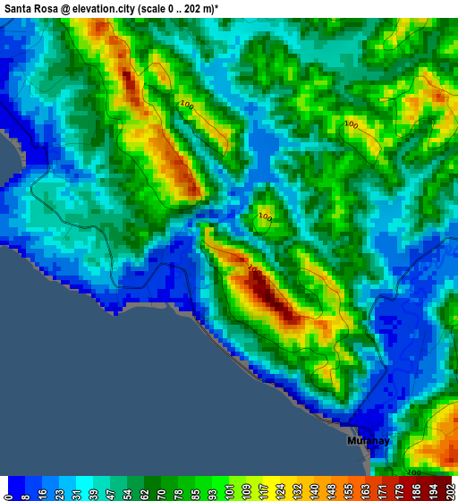
Below is the Elevation map of Santa Rosa, which displays elevation range with different colors. Scale of the first map is from 0 to 202 m (0 to 663 ft) with average elevation of 61.7 meters (=202 ft) [note 1]
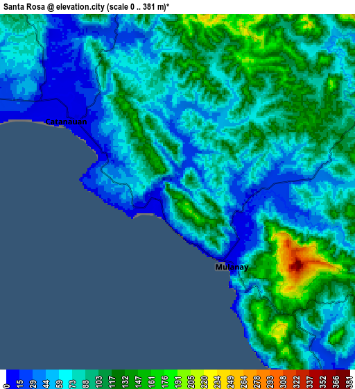
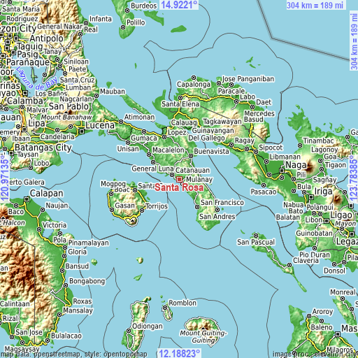
These maps also provides idea of topography and contour of this city, they are displayed at different zoom levels. More info about maps, scale and edge coordinates you can find below images.
| \ | Map #1 | Map #2 | Topo.Map |
| Scale [m] | 0..202 m | 0..381 m | × |
| Scale [ft] | 0..663 ft | 0..1250 ft | × |
| Average | 61.7 m = 202 ft | 84.5 m = 277 ft | × |
| Width | 9.5 km = 5.9 mi | 19 km = 11.8 mi | 304 km = 188.9 mi |
| Height | 9.5 km = 5.9 mi | 19 km = 11.8 mi | 304 km = 188.9 mi |
| ↑Max Latitude | 13.601817° | 13.644526° | 14.9221° |
| Latitude at center | 13.5591° | 13.5591° | 13.5591° |
| ↓Min Latitude | 13.516376° | 13.473644° | 12.18823° |
| ← Min Longitude | 122.333655° | 122.289709° | 120.97135° |
| Longitude center | 122.3776° | 122.3776° | 122.3776° |
| →Max Longitude | 122.421545° | 122.465491° | 123.78385° |
Nearby cities:
Cities around Santa Rosa sort by population:
• Catanauan elevation 7 m
7.1 km,  301°
301°
• Mulanay 6 m
5 km,  144°
144°
• Cambuga 95 m
10.1 km,  50°
50°
• Tagbacan Ibaba 54 m
5 km,  348°
348°
• Abuyon 7 m
16.8 km,  65°
65°
• San Isidro 65 m
16.7 km, 299°
• Madulao 47 m
4.1 km,  284°
284°
• Patabog 29 m
15.4 km,  146°
146°
• Tuhian 41 m
18.6 km,  292°
292°
• Lacdayan 19 m
17.4 km, 74°
• Bagupaye 33 m
1.5 km,  64°
64°
• Tayabas Ibaba 32 m
12.5 km, 304°
Multilingual:
 En español:
Santa Rosa elevación 76 m.
 En France:
Santa Rosa élévation 76 m.
 Auf Deutsch:
Santa Rosa höhe über dem Meeresspiegel ist 76 m.

Sources and notes:
- [note 1] Map square and city borders are not equal. Map elevation data is calculated only from area inside that square.
- [src 1] Elevation data from geonames database provided with same terms of usage.
- [src 2] The elevation map of Santa Rosa is generated using elevation data from NASA's 3 arcsec (90m) resolution SRTM data.
- [src 3] Base (background) map © OpenStreetMap contributors tiles are generated by Geofabrik and OpenTopoMap.
Copyright & License:
This Santa Rosa Elevation Map is licensed under CC BY-SA. You may reuse any part from this page, if you give a proper credit by linking to this URL:
 More info on terms of use page.