Taypano elevation
Taypano (Northern Mindanao, Province of Misamis Oriental), Philippines elevation is 185 meters and Taypano elevation in feet is 607 ft above sea level [src 1]. Taypano is a populated place (feature code) with elevation that is 97 meters (318 ft) bigger than average city elevation in Philippines.
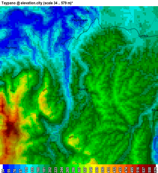
Below is the Elevation map of Taypano, which displays elevation range with different colors. Scale of the first map is from 34 to 579 m (112 to 1900 ft) with average elevation of 208.3 meters (=683 ft) [note 1]
These maps also provides idea of topography and contour of this city, they are displayed at different zoom levels. More info about maps, scale and edge coordinates you can find below images.
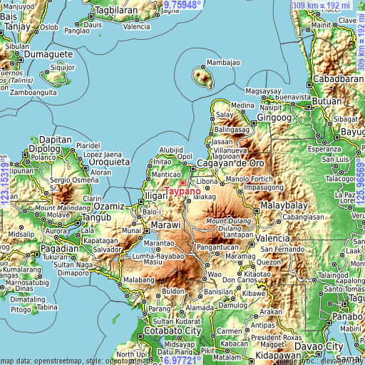
| \ | Map #1 | Topo.Map |
| Scale [m] | 34..579 m | × |
| Scale [ft] | 112..1900 ft | × |
| Average | 208.3 m = 683 ft | × |
| Width | 9.67 km = 6 mi | 309.4 km = 192.3 mi |
| Height | 9.67 km = 6 mi | 309.4 km = 192.3 mi |
| ↑Max Latitude | 8.414305° | 9.75948° |
| Latitude at center | 8.37083° | 8.37083° |
| ↓Min Latitude | 8.32735° | 6.97721° |
| ← Min Longitude | 124.515495° | 123.15319° |
| Longitude center | 124.55944° | 124.55944° |
| →Max Longitude | 124.603385° | 125.96569° |
Nearby cities:
Cities around Taypano sort by population:
• Cagayan de Oro elevation 8 m
15.7 km,  37°
37°
• Barra 1 m
16.3 km,  17°
17°
• Lumbia 154 m
4.7 km,  53°
53°
• Talakag 403 m
15.9 km,  163°
163°
• Igpit 4 m
15.9 km,  10°
10°
• San Isidro 386 m
13 km, 163°
• Tignapalan 403 m
12 km,  171°
171°
• Lingating 277 m
8.8 km,  119°
119°
• Dorsalanam 207 m
7.7 km, 158°
• Opol 16 m
16.8 km,  4°
4°
• Liboran 277 m
10 km,  100°
100°
• Baikingon 86 m
11.3 km,  356°
356°
Multilingual:
 En español:
Taypano elevación 185 m.
 En France:
Taypano élévation 185 m.


Sources and notes:
- [note 1] Map square and city borders are not equal. Map elevation data is calculated only from area inside that square.
- [src 1] Elevation data from geonames database provided with same terms of usage.
- [src 2] The elevation map of Taypano is generated using elevation data from NASA's 3 arcsec (90m) resolution SRTM data.
- [src 3] Base (background) map © OpenStreetMap contributors tiles are generated by Geofabrik and OpenTopoMap.
Copyright & License:
This Taypano Elevation Map is licensed under CC BY-SA. You may reuse any part from this page, if you give a proper credit by linking to this URL:
 More info on terms of use page.