Talakag elevation
Talakag (Northern Mindanao, Province of Bukidnon), Philippines elevation is 403 meters and Talakag elevation in feet is 1322 ft above sea level [src 1]. Talakag is a populated place (feature code) with elevation that is 315 meters (1033 ft) bigger than average city elevation in Philippines.
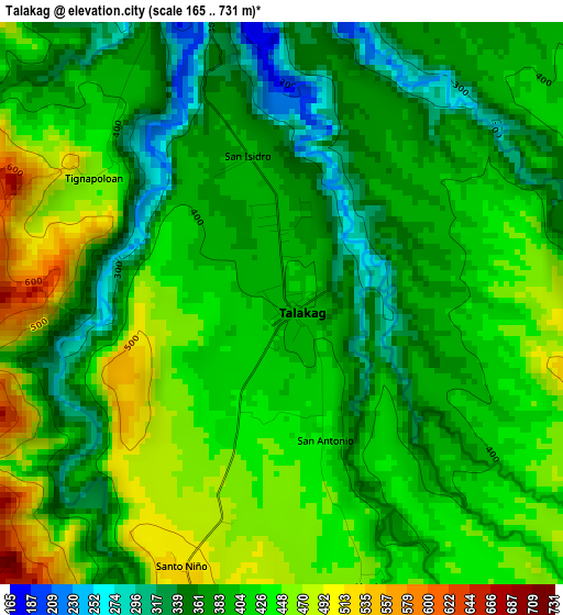
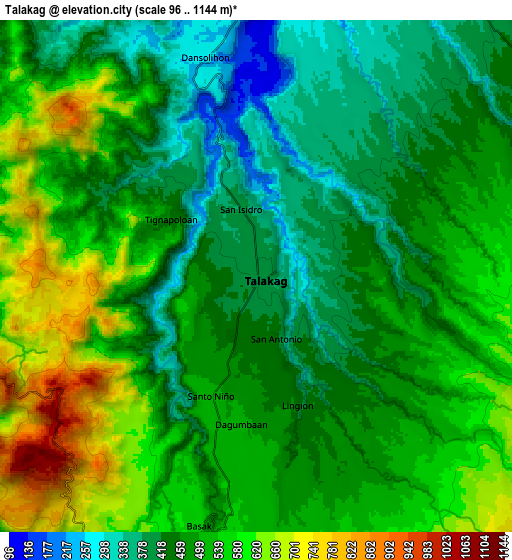
Below is the Elevation map of Talakag, which displays elevation range with different colors. Scale of the first map is from 165 to 731 m (541 to 2398 ft) with average elevation of 405.5 meters (=1330 ft) [note 1]
These maps also provides idea of topography and contour of this city, they are displayed at different zoom levels. More info about maps, scale and edge coordinates you can find below images.
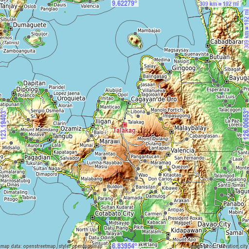
| \ | Map #1 | Map #2 | Topo.Map |
| Scale [m] | 165..731 m | 96..1144 m | × |
| Scale [ft] | 541..2398 ft | 315..3753 ft | × |
| Average | 405.5 m = 1330 ft | 499.3 m = 1638 ft | × |
| Width | 9.67 km = 6 mi | 19.34 km = 12 mi | 309.5 km = 192.3 mi |
| Height | 9.67 km = 6 mi | 19.34 km = 12 mi | 309.5 km = 192.3 mi |
| ↑Max Latitude | 8.2771° | 8.320585° | 9.62279° |
| Latitude at center | 8.23361° | 8.23361° | 8.23361° |
| ↓Min Latitude | 8.190115° | 8.146616° | 6.83954° |
| ← Min Longitude | 124.556335° | 124.512389° | 123.19403° |
| Longitude center | 124.60028° | 124.60028° | 124.60028° |
| →Max Longitude | 124.644225° | 124.688171° | 126.00653° |
Nearby cities:
Cities around Talakag sort by population:
• Dagumba-an elevation 541 m
9 km,  186°
186°
• Lingion 460 m
5.2 km,  168°
168°
• San Isidro 386 m
2.9 km,  343°
343°
• Tignapalan 403 m
4.4 km,  320°
320°
• Lingating 277 m
11.3 km,  16°
16°
• Dorsalanam 207 m
8.3 km,  348°
348°
• Pongol 663 m
17 km,  72°
72°
• Indulang 713 m
16 km, 186°
• Cosina 702 m
14.3 km, 171°
• Taypano 185 m
15.9 km, 343°
• Liboran 277 m
14.5 km, 21°
• Salimbalan 530 m
14.1 km, 71°
Multilingual:
 En español:
Talakag elevación 403 m.
 En France:
Talakag élévation 403 m.


Sources and notes:
- [note 1] Map square and city borders are not equal. Map elevation data is calculated only from area inside that square.
- [src 1] Elevation data from geonames database provided with same terms of usage.
- [src 2] The elevation map of Talakag is generated using elevation data from NASA's 3 arcsec (90m) resolution SRTM data.
- [src 3] Base (background) map © OpenStreetMap contributors tiles are generated by Geofabrik and OpenTopoMap.
Copyright & License:
This Talakag Elevation Map is licensed under CC BY-SA. You may reuse any part from this page, if you give a proper credit by linking to this URL:
 More info on terms of use page.