Tuburan elevation
Tuburan (Bicol, Province of Albay), Philippines elevation is 54 meters and Tuburan elevation in feet is 177 ft above sea level [src 1]. Tuburan is a section of populated place (feature code) with elevation that is 34 meters (112 ft) smaller than average city elevation in Philippines.
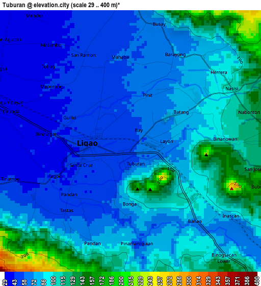
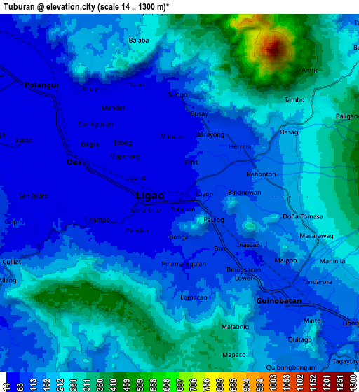
Below is the Elevation map of Tuburan, which displays elevation range with different colors. Scale of the first map is from 29 to 400 m (95 to 1312 ft) with average elevation of 82.2 meters (=270 ft) [note 1]
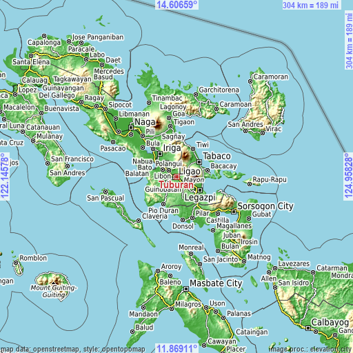
These maps also provides idea of topography and contour of this city, they are displayed at different zoom levels. More info about maps, scale and edge coordinates you can find below images.
| \ | Map #1 | Map #2 | Topo.Map |
| Scale [m] | 29..400 m | 14..1300 m | × |
| Scale [ft] | 95..1312 ft | 46..4265 ft | × |
| Average | 82.2 m = 270 ft | 175 m = 574 ft | × |
| Width | 9.51 km = 5.9 mi | 19.03 km = 11.8 mi | 304.4 km = 189.1 mi |
| Height | 9.51 km = 5.9 mi | 19.03 km = 11.8 mi | 304.4 km = 189.1 mi |
| ↑Max Latitude | 13.284473° | 13.327239° | 14.60659° |
| Latitude at center | 13.2417° | 13.2417° | 13.2417° |
| ↓Min Latitude | 13.198919° | 13.156131° | 11.86911° |
| ← Min Longitude | 123.508085° | 123.464139° | 122.14578° |
| Longitude center | 123.55203° | 123.55203° | 123.55203° |
| →Max Longitude | 123.595975° | 123.639921° | 124.95828° |
Nearby cities:
Cities around Tuburan sort by population:
• Ligao elevation 60 m
4.5 km,  232°
232°
• Muladbucad 178 m
5.8 km,  93°
93°
• Balogo 61 m
5.1 km,  357°
357°
• San Rafael 165 m
5.9 km,  118°
118°
• Mahaba 62 m
2.9 km, 358°
• Balinad 55 m
5.7 km,  352°
352°
• Batana 73 m
1.6 km,  55°
55°
• Iraya 36 m
3.9 km,  283°
283°
• Tinampo 39 m
5.1 km,  252°
252°
• Bonga 67 m
2.8 km,  184°
184°
• Herrera 80 m
4.1 km,  41°
41°
• City of Ligao 70 m
4.9 km,  235°
235°
Multilingual:
 En español:
Tuburan elevación 54 m.
 En France:
Tuburan élévation 54 m.


Sources and notes:
- [note 1] Map square and city borders are not equal. Map elevation data is calculated only from area inside that square.
- [src 1] Elevation data from geonames database provided with same terms of usage.
- [src 2] The elevation map of Tuburan is generated using elevation data from NASA's 3 arcsec (90m) resolution SRTM data.
- [src 3] Base (background) map © OpenStreetMap contributors tiles are generated by Geofabrik and OpenTopoMap.
Copyright & License:
This Tuburan Elevation Map is licensed under CC BY-SA. You may reuse any part from this page, if you give a proper credit by linking to this URL:
 More info on terms of use page.