Tuyan elevation
Tuyan (Soccsksargen, Province of South Cotabato), Philippines elevation is 1 meters and Tuyan elevation in feet is 3 ft above sea level [src 1]. Tuyan is a populated place (feature code) with elevation that is 87 meters (285 ft) smaller than average city elevation in Philippines.
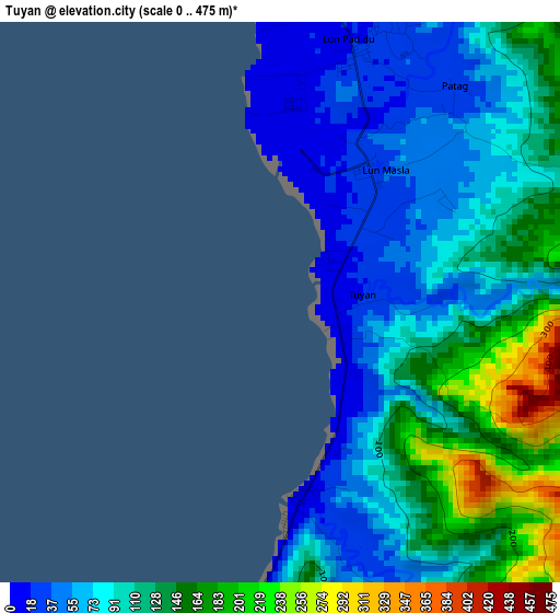
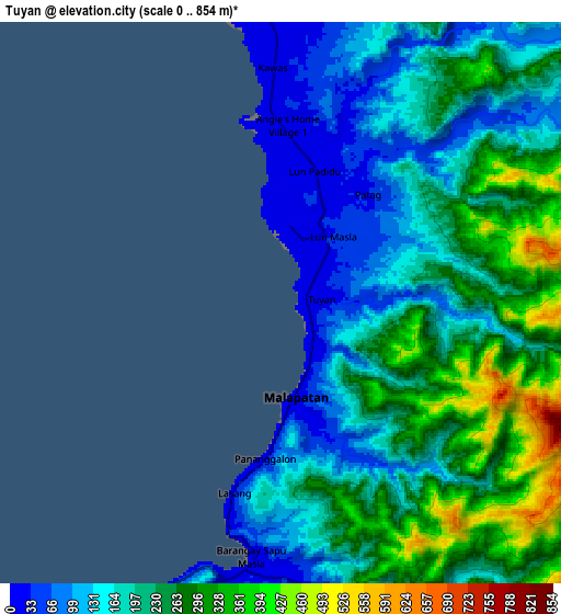
Below is the Elevation map of Tuyan, which displays elevation range with different colors. Scale of the first map is from 0 to 475 m (0 to 1558 ft) with average elevation of 102.7 meters (=337 ft) [note 1]
These maps also provides idea of topography and contour of this city, they are displayed at different zoom levels. More info about maps, scale and edge coordinates you can find below images.
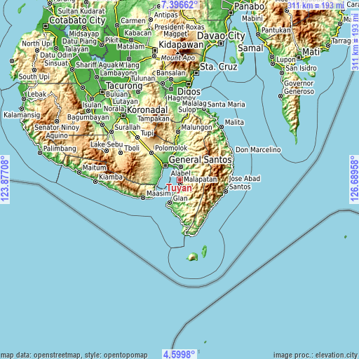
| \ | Map #1 | Map #2 | Topo.Map |
| Scale [m] | 0..475 m | 0..854 m | × |
| Scale [ft] | 0..1558 ft | 0..2802 ft | × |
| Average | 102.7 m = 337 ft | 209 m = 686 ft | × |
| Width | 9.72 km = 6 mi | 19.44 km = 12.1 mi | 311 km = 193.2 mi |
| Height | 9.72 km = 6 mi | 19.44 km = 12.1 mi | 311 km = 193.2 mi |
| ↑Max Latitude | 6.043703° | 6.087402° | 7.39662° |
| Latitude at center | 6° | 6° | 6° |
| ↓Min Latitude | 5.956294° | 5.912584° | 4.5998° |
| ← Min Longitude | 125.239385° | 125.195439° | 123.87708° |
| Longitude center | 125.28333° | 125.28333° | 125.28333° |
| →Max Longitude | 125.327275° | 125.371221° | 126.68958° |
Nearby cities:
Cities around Tuyan sort by population:
• General Santos elevation 22 m
17.6 km,  315°
315°
• Alabel 40 m
11.3 km,  3°
3°
• Malapatan 26 m
3.5 km,  168°
168°
• Buayan 13 m
14 km,  337°
337°
• Lun Pequeño 13 m
4.2 km, 0°
• Sapu Padidu 2 m
9.4 km,  191°
191°
• Katangawan 38 m
20.3 km, 340°
• Suyan 112 m
13.1 km,  59°
59°
• Glan Peidu 10 m
17.6 km,  203°
203°
• Kiupo 324 m
18 km, 167°
• Kapatan 27 m
12.2 km, 204°
• Tañgo 17 m
14.9 km,  207°
207°
Multilingual:
 En español:
Tuyan elevación 1 m.
 En France:
Tuyan élévation 1 m.


Sources and notes:
- [note 1] Map square and city borders are not equal. Map elevation data is calculated only from area inside that square.
- [src 1] Elevation data from geonames database provided with same terms of usage.
- [src 2] The elevation map of Tuyan is generated using elevation data from NASA's 3 arcsec (90m) resolution SRTM data.
- [src 3] Base (background) map © OpenStreetMap contributors tiles are generated by Geofabrik and OpenTopoMap.
Copyright & License:
This Tuyan Elevation Map is licensed under CC BY-SA. You may reuse any part from this page, if you give a proper credit by linking to this URL:
 More info on terms of use page.