Anta elevation
Anta (Cusco, Provincia de Anta), Peru elevation is 3431 meters and Anta elevation in feet is 11257 ft above sea level [src 1]. Anta is a seat of a third-order administrative division (feature code) with elevation that is 1110 meters (3642 ft) bigger than average city elevation in Peru.
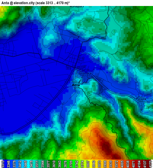
Below is the Elevation map of Anta, which displays elevation range with different colors. Scale of the first map is from 3313 to 4170 m (10869 to 13681 ft) with average elevation of 3495.4 meters (=11468 ft) [note 1]
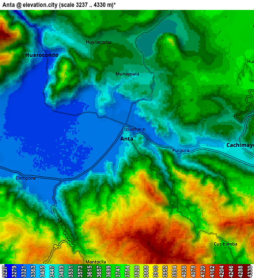
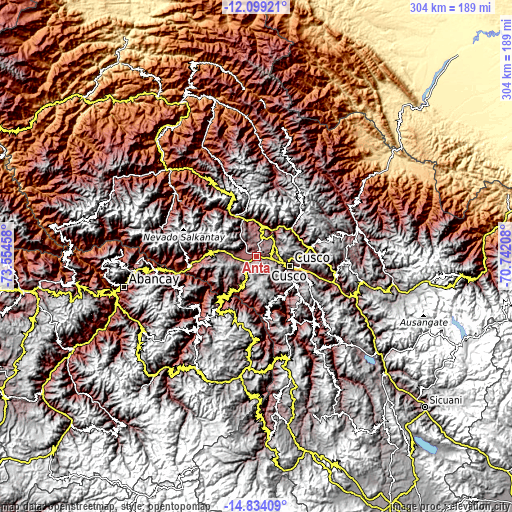
These maps also provides idea of topography and contour of this city, they are displayed at different zoom levels. More info about maps, scale and edge coordinates you can find below images.
| \ | Map #1 | Map #2 | Topo.Map |
| Scale [m] | 3313..4170 m | 3237..4330 m | × |
| Scale [ft] | 10869..13681 ft | 10620..14206 ft | × |
| Average | 3495.4 m = 11468 ft | 3624.2 m = 11890 ft | × |
| Width | 9.5 km = 5.9 mi | 19.01 km = 11.8 mi | 304.1 km = 189 mi |
| Height | 9.5 km = 5.9 mi | 19.01 km = 11.8 mi | 304.1 km = 189 mi |
| ↑Max Latitude | -13.42782° | -13.385072° | -12.09921° |
| Latitude at center | -13.47056° | -13.47056° | -13.47056° |
| ↓Min Latitude | -13.513293° | -13.556017° | -14.83409° |
| ← Min Longitude | -72.192275° | -72.236221° | -73.55458° |
| Longitude center | -72.14833° | -72.14833° | -72.14833° |
| →Max Longitude | -72.104385° | -72.060439° | -70.74208° |
Nearby cities:
Cities around Anta sort by population:
• Urubamba elevation 2875 m
18.8 km,  10°
10°
• Yucay 2856 m
18.1 km,  23°
23°
• Ancahuasi 3689 m
17.8 km,  280°
280°
• Huayllabamba 2868 m
17.3 km,  31°
31°
• Ccorca 3630 m
15.9 km,  143°
143°
• Maras 3378 m
15.1 km,  356°
356°
• Chinchero 3749 m
13.9 km,  51°
51°
• Zurite 3404 m
11.7 km, 278°
• Poroy 3490 m
11.7 km,  103°
103°
• Huarocondo 3329 m
8.9 km,  315°
315°
• Cachimayo 3424 m
8.3 km,  94°
94°
• Pucyura 3380 m
4.1 km, 103°
Multilingual:
 En español:
Anta elevación 3431 m.
 En France:
Anta élévation 3431 m.


Sources and notes:
- [note 1] Map square and city borders are not equal. Map elevation data is calculated only from area inside that square.
- [src 1] Elevation data from geonames database provided with same terms of usage.
- [src 2] The elevation map of Anta is generated using elevation data from NASA's 3 arcsec (90m) resolution SRTM data.
- [src 3] Base (background) map © OpenStreetMap contributors tiles are generated by Geofabrik and OpenTopoMap.
Copyright & License:
This Anta Elevation Map is licensed under CC BY-SA. You may reuse any part from this page, if you give a proper credit by linking to this URL:
 More info on terms of use page.