Azángaro elevation
Azángaro (Puno, Provincia de Azángaro), Peru elevation is 3868 meters and Azángaro elevation in feet is 12690 ft above sea level [src 1]. Azángaro is a populated place (feature code) with elevation that is 1547 meters (5075 ft) bigger than average city elevation in Peru.
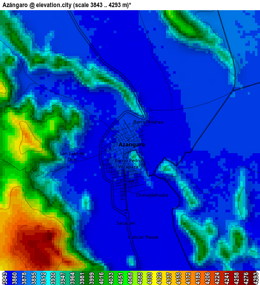
Below is the Elevation map of Azángaro, which displays elevation range with different colors. Scale of the first map is from 3843 to 4293 m (12608 to 14085 ft) with average elevation of 3913.6 meters (=12840 ft) [note 1]
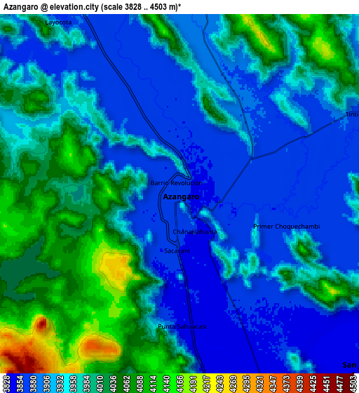
These maps also provides idea of topography and contour of this city, they are displayed at different zoom levels. More info about maps, scale and edge coordinates you can find below images.
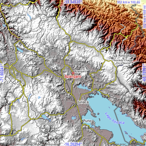
| \ | Map #1 | Map #2 | Topo.Map |
| Scale [m] | 3843..4293 m | 3828..4503 m | × |
| Scale [ft] | 12608..14085 ft | 12559..14774 ft | × |
| Average | 3913.6 m = 12840 ft | 3955 m = 12976 ft | × |
| Width | 9.44 km = 5.9 mi | 18.89 km = 11.7 mi | 302.2 km = 187.8 mi |
| Height | 9.44 km = 5.9 mi | 18.89 km = 11.7 mi | 302.2 km = 187.8 mi |
| ↑Max Latitude | -14.86596° | -14.823481° | -13.54535° |
| Latitude at center | -14.90843° | -14.90843° | -14.90843° |
| ↓Min Latitude | -14.950892° | -14.993345° | -16.26294° |
| ← Min Longitude | -70.240105° | -70.284051° | -71.60241° |
| Longitude center | -70.19616° | -70.19616° | -70.19616° |
| →Max Longitude | -70.152215° | -70.108269° | -68.78991° |
Nearby cities:
Cities around Azángaro sort by population:
• Ayaviri elevation 3898 m
42.3 km,  273°
273°
• Calapuja 3842 m
45.4 km,  182°
182°
• Achaya 3852 m
40.1 km,  172°
172°
• Orurillo 3954 m
39.4 km,  300°
300°
• Ayrampuni 3858 m
37.1 km,  115°
115°
• Nicasio 3851 m
36.6 km,  189°
189°
• Putina 3863 m
35.4 km,  91°
91°
• Chupa 3894 m
31.2 km,  132°
132°
• Muñani 3927 m
30.8 km,  59°
59°
• Arapa 3916 m
26.4 km,  161°
161°
• Tirapata 3887 m
22.4 km,  258°
258°
• Asillo 3903 m
21.6 km,  310°
310°
Multilingual:
 En español:
Azángaro elevación 3868 m.
 En France:
Azángaro élévation 3868 m.
 Auf Deutsch:
Azángaro höhe über dem Meeresspiegel ist 3868 m.

Sources and notes:
- [note 1] Map square and city borders are not equal. Map elevation data is calculated only from area inside that square.
- [src 1] Elevation data from geonames database provided with same terms of usage.
- [src 2] The elevation map of Azángaro is generated using elevation data from NASA's 3 arcsec (90m) resolution SRTM data.
- [src 3] Base (background) map © OpenStreetMap contributors tiles are generated by Geofabrik and OpenTopoMap.
Copyright & License:
This Azángaro Elevation Map is licensed under CC BY-SA. You may reuse any part from this page, if you give a proper credit by linking to this URL:
 More info on terms of use page.