Cabanilla elevation
Cabanilla (Puno, Provincia de Lampa), Peru elevation is 3883 meters and Cabanilla elevation in feet is 12740 ft above sea level [src 1]. Cabanilla is a seat of a third-order administrative division (feature code) with elevation that is 1562 meters (5125 ft) bigger than average city elevation in Peru.
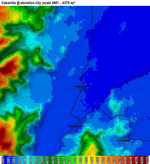
Below is the Elevation map of Cabanilla, which displays elevation range with different colors. Scale of the first map is from 3861 to 4375 m (12667 to 14354 ft) with average elevation of 3942.4 meters (=12934 ft) [note 1]
These maps also provides idea of topography and contour of this city, they are displayed at different zoom levels. More info about maps, scale and edge coordinates you can find below images.
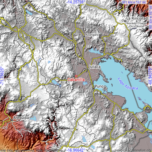
| \ | Map #1 | Topo.Map |
| Scale [m] | 3861..4375 m | × |
| Scale [ft] | 12667..14354 ft | × |
| Average | 3942.4 m = 12934 ft | × |
| Width | 9.41 km = 5.8 mi | 301.2 km = 187.2 mi |
| Height | 9.41 km = 5.8 mi | 301.2 km = 187.2 mi |
| ↑Max Latitude | -15.574343° | -14.25798° |
| Latitude at center | -15.61667° | -15.61667° |
| ↓Min Latitude | -15.658989° | -16.96642° |
| ← Min Longitude | -70.393945° | -71.75625° |
| Longitude center | -70.35° | -70.35° |
| →Max Longitude | -70.306055° | -68.94375° |
Nearby cities:
Cities around Cabanilla sort by population:
• Juliaca elevation 3834 m
26.6 km,  60°
60°
• Atuncolla 3828 m
22.7 km,  109°
109°
• Lampa 3874 m
29.7 km,  356°
356°
• Santa Lucía 4046 m
28.9 km,  251°
251°
• Calapuja 3842 m
36.3 km,  23°
23°
• Paucarcolla 3819 m
34.6 km, 111°
• Paratia 4363 m
32.3 km,  304°
304°
• Tiquillaca 3855 m
27.4 km,  144°
144°
• Caracoto 3828 m
27.3 km,  78°
78°
• Mañazo 3918 m
20.5 km,  174°
174°
• Vilque 3845 m
19.8 km,  147°
147°
• Cabana 3897 m
5.1 km, 136°
Multilingual:
 En español:
Cabanilla elevación 3883 m.
 En France:
Cabanilla élévation 3883 m.
 Auf Deutsch:
Cabanilla höhe über dem Meeresspiegel ist 3883 m.

Sources and notes:
- [note 1] Map square and city borders are not equal. Map elevation data is calculated only from area inside that square.
- [src 1] Elevation data from geonames database provided with same terms of usage.
- [src 2] The elevation map of Cabanilla is generated using elevation data from NASA's 3 arcsec (90m) resolution SRTM data.
- [src 3] Base (background) map © OpenStreetMap contributors tiles are generated by Geofabrik and OpenTopoMap.
Copyright & License:
This Cabanilla Elevation Map is licensed under CC BY-SA. You may reuse any part from this page, if you give a proper credit by linking to this URL:
 More info on terms of use page.