Carapo elevation
Carapo (Ayacucho, Provincia de Huanca Sancos), Peru elevation is 3265 meters and Carapo elevation in feet is 10712 ft above sea level [src 1]. Carapo is a seat of a third-order administrative division (feature code) with elevation that is 944 meters (3097 ft) bigger than average city elevation in Peru.
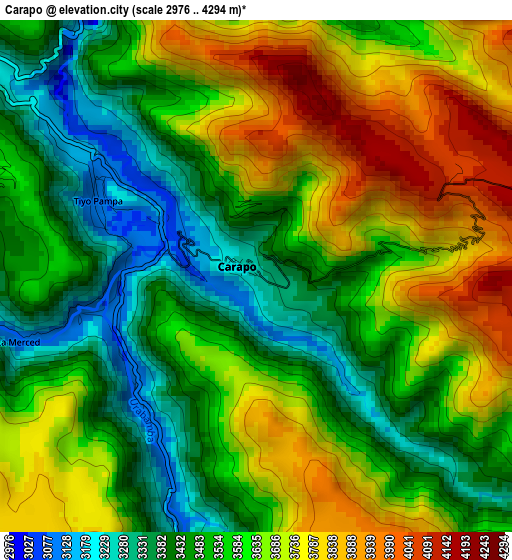
Below is the Elevation map of Carapo, which displays elevation range with different colors. Scale of the first map is from 2976 to 4294 m (9764 to 14088 ft) with average elevation of 3587.1 meters (=11769 ft) [note 1]
These maps also provides idea of topography and contour of this city, they are displayed at different zoom levels. More info about maps, scale and edge coordinates you can find below images.
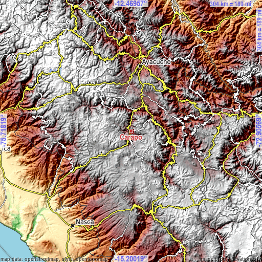
| \ | Map #1 | Topo.Map |
| Scale [m] | 2976..4294 m | × |
| Scale [ft] | 9764..14088 ft | × |
| Average | 3587.1 m = 11769 ft | × |
| Width | 9.49 km = 5.9 mi | 303.6 km = 188.6 mi |
| Height | 9.49 km = 5.9 mi | 303.6 km = 188.6 mi |
| ↑Max Latitude | -13.796216° | -12.46957° |
| Latitude at center | -13.83889° | -13.83889° |
| ↓Min Latitude | -13.881556° | -15.20019° |
| ← Min Longitude | -74.355885° | -75.71819° |
| Longitude center | -74.31194° | -74.31194° |
| →Max Longitude | -74.267995° | -72.90569° |
Nearby cities:
Cities around Carapo sort by population:
• Totos elevation 3308 m
37.9 km,  322°
322°
• Cayara 3191 m
35.2 km,  81°
81°
• Vilcanchos 2993 m
34.7 km, 316°
• Pampa Cangallo 3311 m
33.6 km,  22°
22°
• Colca 3025 m
33.1 km,  65°
65°
• Cangallo 2565 m
29.6 km,  37°
37°
• Chuschi 3134 m
28.5 km,  351°
351°
• Huancapi 3178 m
28 km, 70°
• Pomabamba 3247 m
27.4 km, 17°
• Sarhua 3138 m
18.3 km,  357°
357°
• Huamanquiquia 3393 m
12.8 km, 19°
• Sacsamarca 3460 m
12 km,  179°
179°
Multilingual:
 En español:
Carapo elevación 3265 m.
 En France:
Carapo élévation 3265 m.


Sources and notes:
- [note 1] Map square and city borders are not equal. Map elevation data is calculated only from area inside that square.
- [src 1] Elevation data from geonames database provided with same terms of usage.
- [src 2] The elevation map of Carapo is generated using elevation data from NASA's 3 arcsec (90m) resolution SRTM data.
- [src 3] Base (background) map © OpenStreetMap contributors tiles are generated by Geofabrik and OpenTopoMap.
Copyright & License:
This Carapo Elevation Map is licensed under CC BY-SA. You may reuse any part from this page, if you give a proper credit by linking to this URL:
 More info on terms of use page.