Congas elevation
Congas (Ancash, Ocros), Peru elevation is 3078 meters and Congas elevation in feet is 10098 ft above sea level [src 1]. Congas is a seat of a third-order administrative division (feature code) with elevation that is 757 meters (2484 ft) bigger than average city elevation in Peru.
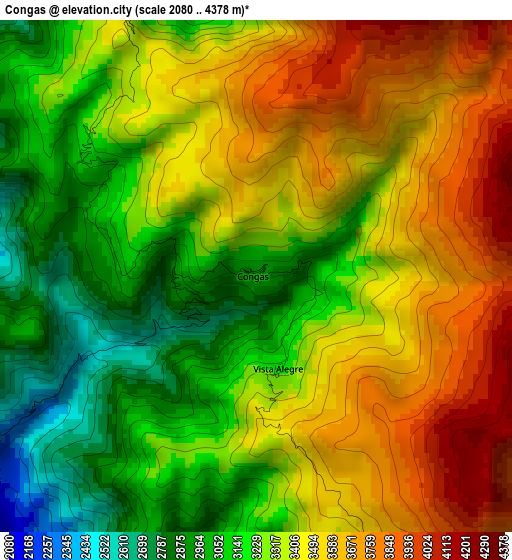
Below is the Elevation map of Congas, which displays elevation range with different colors. Scale of the first map is from 2080 to 4378 m (6824 to 14364 ft) with average elevation of 3346.8 meters (=10980 ft) [note 1]
These maps also provides idea of topography and contour of this city, they are displayed at different zoom levels. More info about maps, scale and edge coordinates you can find below images.
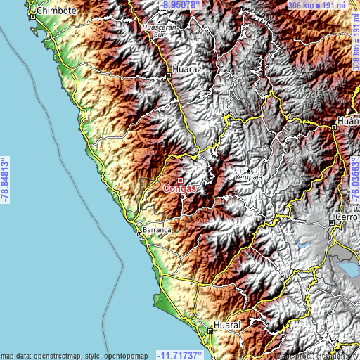
| \ | Map #1 | Topo.Map |
| Scale [m] | 2080..4378 m | × |
| Scale [ft] | 6824..14364 ft | × |
| Average | 3346.8 m = 10980 ft | × |
| Width | 9.61 km = 6 mi | 307.6 km = 191.1 mi |
| Height | 9.61 km = 6 mi | 307.6 km = 191.1 mi |
| ↑Max Latitude | -10.293885° | -8.95078° |
| Latitude at center | -10.33712° | -10.33712° |
| ↓Min Latitude | -10.380349° | -11.71737° |
| ← Min Longitude | -77.485825° | -78.84813° |
| Longitude center | -77.44188° | -77.44188° |
| →Max Longitude | -77.397935° | -76.03563° |
Nearby cities:
Cities around Congas sort by population:
• Canis elevation 2457 m
29.8 km,  90°
90°
• Ticllos 3644 m
29 km,  71°
71°
• Aco 2229 m
28.2 km,  129°
129°
• Marca 2635 m
27.9 km,  352°
352°
• Corpanqui 3381 m
27.2 km,  77°
77°
• Llipa 3009 m
26.3 km,  100°
100°
• Pampas Chico 3538 m
25.1 km,  11°
11°
• Cajacay 2613 m
20.2 km,  0°
0°
• Acas 3700 m
18.4 km,  136°
136°
• Chasquitambo 874 m
17.8 km,  283°
283°
• Ocros 3238 m
8.8 km,  145°
145°
• Copa 2239 m
6.3 km,  232°
232°
Multilingual:
 En español:
Congas elevación 3078 m.
 En France:
Congas élévation 3078 m.


Sources and notes:
- [note 1] Map square and city borders are not equal. Map elevation data is calculated only from area inside that square.
- [src 1] Elevation data from geonames database provided with same terms of usage.
- [src 2] The elevation map of Congas is generated using elevation data from NASA's 3 arcsec (90m) resolution SRTM data.
- [src 3] Base (background) map © OpenStreetMap contributors tiles are generated by Geofabrik and OpenTopoMap.
Copyright & License:
This Congas Elevation Map is licensed under CC BY-SA. You may reuse any part from this page, if you give a proper credit by linking to this URL:
 More info on terms of use page.