Cotahuasi elevation
Cotahuasi (Arequipa, Provincia de La Unión), Peru elevation is 2686 meters and Cotahuasi elevation in feet is 8812 ft above sea level [src 1]. Cotahuasi is a seat of a third-order administrative division (feature code) with elevation that is 365 meters (1198 ft) bigger than average city elevation in Peru.
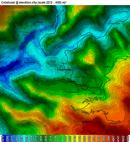
Below is the Elevation map of Cotahuasi, which displays elevation range with different colors. Scale of the first map is from 2212 to 4302 m (7257 to 14114 ft) with average elevation of 3080.7 meters (=10107 ft) [note 1]
These maps also provides idea of topography and contour of this city, they are displayed at different zoom levels. More info about maps, scale and edge coordinates you can find below images.
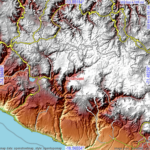
| \ | Map #1 | Topo.Map |
| Scale [m] | 2212..4302 m | × |
| Scale [ft] | 7257..14114 ft | × |
| Average | 3080.7 m = 10107 ft | × |
| Width | 9.43 km = 5.9 mi | 301.7 km = 187.5 mi |
| Height | 9.43 km = 5.9 mi | 301.8 km = 187.5 mi |
| ↑Max Latitude | -15.17065° | -13.85184° |
| Latitude at center | -15.21306° | -15.21306° |
| ↓Min Latitude | -15.255461° | -16.56554° |
| ← Min Longitude | -72.932555° | -74.29486° |
| Longitude center | -72.88861° | -72.88861° |
| →Max Longitude | -72.844665° | -71.48236° |
Nearby cities:
Cities around Cotahuasi sort by population:
• Tauria elevation 2886 m
40.2 km,  246°
246°
• Chichas 2152 m
37.3 km,  184°
184°
• Corculla 3482 m
33.9 km,  260°
260°
• Oyolo 3394 m
32.1 km,  276°
276°
• Puyca 3650 m
27.2 km,  51°
51°
• Charcana 3403 m
19.8 km, 261°
• Alca 2731 m
15.9 km,  56°
56°
• Velinga 1962 m
15.8 km,  244°
244°
• Tomepampa 2624 m
7.6 km, 54°
• Toro 2953 m
7.1 km,  217°
217°
• Taurisma 2596 m
5.9 km,  44°
44°
• Mungui 2585 m
3.8 km,  331°
331°
Multilingual:
 En español:
Cotahuasi elevación 2686 m.
 En France:
Cotahuasi élévation 2686 m.
 Auf Deutsch:
Cotahuasi höhe über dem Meeresspiegel ist 2686 m.

Sources and notes:
- [note 1] Map square and city borders are not equal. Map elevation data is calculated only from area inside that square.
- [src 1] Elevation data from geonames database provided with same terms of usage.
- [src 2] The elevation map of Cotahuasi is generated using elevation data from NASA's 3 arcsec (90m) resolution SRTM data.
- [src 3] Base (background) map © OpenStreetMap contributors tiles are generated by Geofabrik and OpenTopoMap.
Copyright & License:
This Cotahuasi Elevation Map is licensed under CC BY-SA. You may reuse any part from this page, if you give a proper credit by linking to this URL:
 More info on terms of use page.