Huanta elevation
Huanta (Ayacucho, Provincia de Huanta), Peru elevation is 2659 meters and Huanta elevation in feet is 8724 ft above sea level [src 1]. Huanta is a seat of a third-order administrative division (feature code) with elevation that is 338 meters (1109 ft) bigger than average city elevation in Peru.
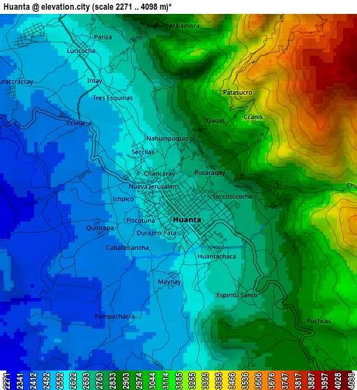
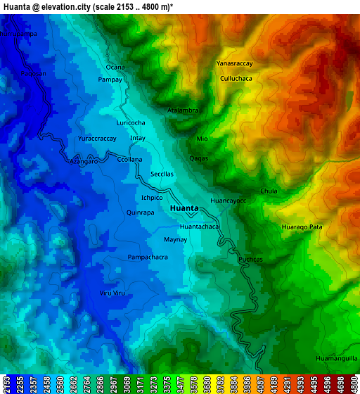
Below is the Elevation map of Huanta, which displays elevation range with different colors. Scale of the first map is from 2271 to 4098 m (7451 to 13445 ft) with average elevation of 2789.5 meters (=9152 ft) [note 1]
These maps also provides idea of topography and contour of this city, they are displayed at different zoom levels. More info about maps, scale and edge coordinates you can find below images.
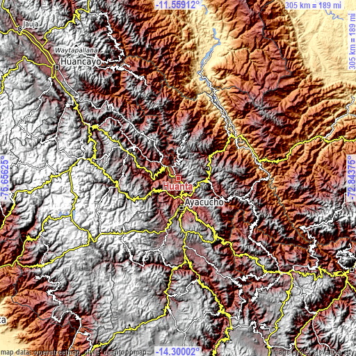
| \ | Map #1 | Map #2 | Topo.Map |
| Scale [m] | 2271..4098 m | 2153..4800 m | × |
| Scale [ft] | 7451..13445 ft | 7064..15748 ft | × |
| Average | 2789.5 m = 9152 ft | 3026 m = 9928 ft | × |
| Width | 9.52 km = 5.9 mi | 19.05 km = 11.8 mi | 304.8 km = 189.4 mi |
| Height | 9.52 km = 5.9 mi | 19.05 km = 11.8 mi | 304.8 km = 189.4 mi |
| ↑Max Latitude | -12.890496° | -12.847654° | -11.55912° |
| Latitude at center | -12.93333° | -12.93333° | -12.93333° |
| ↓Min Latitude | -12.976157° | -13.018976° | -14.30002° |
| ← Min Longitude | -74.293945° | -74.337891° | -75.65625° |
| Longitude center | -74.25° | -74.25° | -74.25° |
| →Max Longitude | -74.206055° | -74.162109° | -72.84375° |
Nearby cities:
Cities around Huanta sort by population:
• Caja elevation 3486 m
24.1 km,  283°
283°
• Ticllas 3277 m
23.9 km,  202°
202°
• Antaparco 2759 m
23.5 km,  228°
228°
• Mayocc 2717 m
23.3 km,  315°
315°
• Julcamarca 3438 m
22.6 km,  247°
247°
• Quinua 3286 m
17.7 km,  136°
136°
• Marcas 3298 m
15.5 km,  291°
291°
• Pacaycasa 2563 m
14.3 km,  163°
163°
• Chincho 3027 m
13.2 km, 253°
• Huamanguilla 3225 m
11.6 km, 137°
• Luricocha 3672 m
9.4 km,  348°
348°
• Macachacra 3121 m
7.8 km, 135°
Multilingual:
 En español:
Huanta elevación 2659 m.
 En France:
Huanta élévation 2659 m.


Sources and notes:
- [note 1] Map square and city borders are not equal. Map elevation data is calculated only from area inside that square.
- [src 1] Elevation data from geonames database provided with same terms of usage.
- [src 2] The elevation map of Huanta is generated using elevation data from NASA's 3 arcsec (90m) resolution SRTM data.
- [src 3] Base (background) map © OpenStreetMap contributors tiles are generated by Geofabrik and OpenTopoMap.
Copyright & License:
This Huanta Elevation Map is licensed under CC BY-SA. You may reuse any part from this page, if you give a proper credit by linking to this URL:
 More info on terms of use page.