Jauja elevation
Jauja (Junin, Provincia de Jauja), Peru elevation is 3380 meters and Jauja elevation in feet is 11089 ft above sea level [src 1]. Jauja is a seat of a third-order administrative division (feature code) with elevation that is 1059 meters (3474 ft) bigger than average city elevation in Peru.
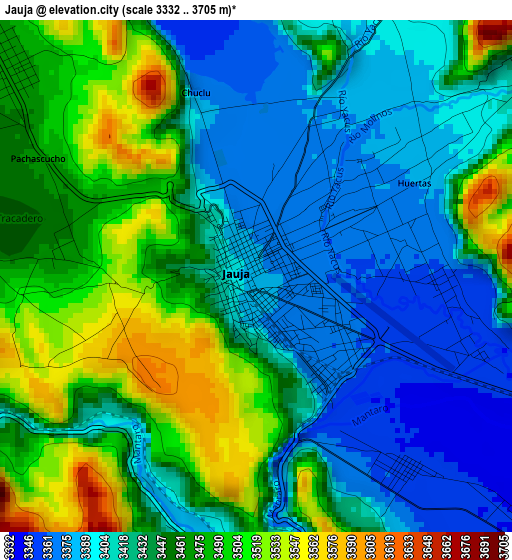
Below is the Elevation map of Jauja, which displays elevation range with different colors. Scale of the first map is from 3332 to 3705 m (10932 to 12156 ft) with average elevation of 3442.8 meters (=11295 ft) [note 1]
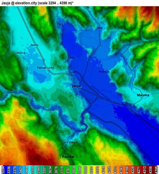
These maps also provides idea of topography and contour of this city, they are displayed at different zoom levels. More info about maps, scale and edge coordinates you can find below images.
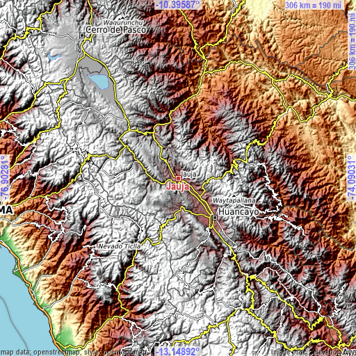
| \ | Map #1 | Map #2 | Topo.Map |
| Scale [m] | 3332..3705 m | 3294..4398 m | × |
| Scale [ft] | 10932..12156 ft | 10807..14429 ft | × |
| Average | 3442.8 m = 11295 ft | 3611.1 m = 11847 ft | × |
| Width | 9.57 km = 5.9 mi | 19.13 km = 11.9 mi | 306.1 km = 190.2 mi |
| Height | 9.57 km = 5.9 mi | 19.13 km = 11.9 mi | 306.1 km = 190.2 mi |
| ↑Max Latitude | -11.732816° | -11.689786° | -10.39587° |
| Latitude at center | -11.77584° | -11.77584° | -11.77584° |
| ↓Min Latitude | -11.818857° | -11.861867° | -13.14892° |
| ← Min Longitude | -75.540505° | -75.584451° | -76.90281° |
| Longitude center | -75.49656° | -75.49656° | -75.49656° |
| →Max Longitude | -75.452615° | -75.408669° | -74.09031° |
Nearby cities:
Cities around Jauja sort by population:
• Acolla elevation 3465 m
7.3 km,  312°
312°
• Yauli 3418 m
7.3 km,  19°
19°
• Molinos 3449 m
7.2 km,  52°
52°
• Paca 3378 m
7 km,  342°
342°
• Ataura 3342 m
6.8 km,  114°
114°
• Julcan 3448 m
6.8 km,  75°
75°
• Muquiyauyo 3345 m
6.2 km,  132°
132°
• Parco 3410 m
6 km,  243°
243°
• Huaripampa 3356 m
4.5 km,  142°
142°
• Pancan 3375 m
3.2 km, 20°
• Huertas 3364 m
2.6 km,  70°
70°
• Sausa 3366 m
2.4 km, 144°
Multilingual:
 En español:
Jauja elevación 3380 m.
 En France:
Jauja élévation 3380 m.


Sources and notes:
- [note 1] Map square and city borders are not equal. Map elevation data is calculated only from area inside that square.
- [src 1] Elevation data from geonames database provided with same terms of usage.
- [src 2] The elevation map of Jauja is generated using elevation data from NASA's 3 arcsec (90m) resolution SRTM data.
- [src 3] Base (background) map © OpenStreetMap contributors tiles are generated by Geofabrik and OpenTopoMap.
Copyright & License:
This Jauja Elevation Map is licensed under CC BY-SA. You may reuse any part from this page, if you give a proper credit by linking to this URL:
 More info on terms of use page.