Kishuara elevation
Kishuara (Apurímac, Provincia de Andahuaylas), Peru elevation is 3716 meters and Kishuara elevation in feet is 12192 ft above sea level [src 1]. Kishuara is a seat of a third-order administrative division (feature code) with elevation that is 1395 meters (4577 ft) bigger than average city elevation in Peru.
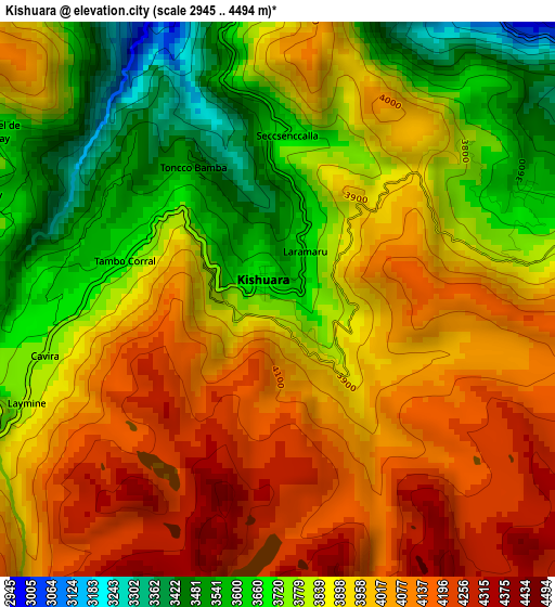
Below is the Elevation map of Kishuara, which displays elevation range with different colors. Scale of the first map is from 2945 to 4494 m (9662 to 14744 ft) with average elevation of 3895.4 meters (=12780 ft) [note 1]
These maps also provides idea of topography and contour of this city, they are displayed at different zoom levels. More info about maps, scale and edge coordinates you can find below images.
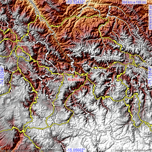
| \ | Map #1 | Topo.Map |
| Scale [m] | 2945..4494 m | × |
| Scale [ft] | 9662..14744 ft | × |
| Average | 3895.4 m = 12780 ft | × |
| Width | 9.49 km = 5.9 mi | 303.8 km = 188.8 mi |
| Height | 9.49 km = 5.9 mi | 303.8 km = 188.8 mi |
| ↑Max Latitude | -13.65174° | -12.32432° |
| Latitude at center | -13.69444° | -13.69444° |
| ↓Min Latitude | -13.737132° | -15.05662° |
| ← Min Longitude | -73.160335° | -74.52264° |
| Longitude center | -73.11639° | -73.11639° |
| →Max Longitude | -73.072445° | -71.71014° |
Nearby cities:
Cities around Kishuara sort by population:
• Abancay elevation 2410 m
26.3 km,  75°
75°
• Andahuaylas 2902 m
29.6 km,  278°
278°
• San Jerónimo 2958 m
27.2 km, 280°
• Lucre 2797 m
30.7 km,  202°
202°
• Tintay 2780 m
30.4 km,  194°
194°
• Huanipaca 3316 m
29.3 km,  42°
42°
• Tamburco 2664 m
27.8 km,  71°
71°
• Pacucha 3132 m
26.3 km,  291°
291°
• San Pedro De Cachora 2407 m
26.1 km, 74°
• Pichirhua 2746 m
19.1 km,  165°
165°
• Pacobamba 2743 m
9.3 km,  20°
20°
• Huancarama 2977 m
6.4 km,  30°
30°
Multilingual:
 En español:
Kishuara elevación 3716 m.
 En France:
Kishuara élévation 3716 m.
 Auf Deutsch:
Kishuara höhe über dem Meeresspiegel ist 3716 m.

Sources and notes:
- [note 1] Map square and city borders are not equal. Map elevation data is calculated only from area inside that square.
- [src 1] Elevation data from geonames database provided with same terms of usage.
- [src 2] The elevation map of Kishuara is generated using elevation data from NASA's 3 arcsec (90m) resolution SRTM data.
- [src 3] Base (background) map © OpenStreetMap contributors tiles are generated by Geofabrik and OpenTopoMap.
Copyright & License:
This Kishuara Elevation Map is licensed under CC BY-SA. You may reuse any part from this page, if you give a proper credit by linking to this URL:
 More info on terms of use page.