Leticia elevation
Leticia (Junin, Provincia de Tarma), Peru elevation is 3547 meters and Leticia elevation in feet is 11637 ft above sea level [src 1]. Leticia is a seat of a third-order administrative division (feature code) with elevation that is 1226 meters (4022 ft) bigger than average city elevation in Peru.
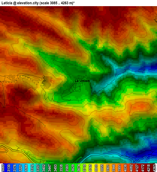
Below is the Elevation map of Leticia, which displays elevation range with different colors. Scale of the first map is from 3085 to 4263 m (10121 to 13986 ft) with average elevation of 3800.6 meters (=12469 ft) [note 1]
These maps also provides idea of topography and contour of this city, they are displayed at different zoom levels. More info about maps, scale and edge coordinates you can find below images.
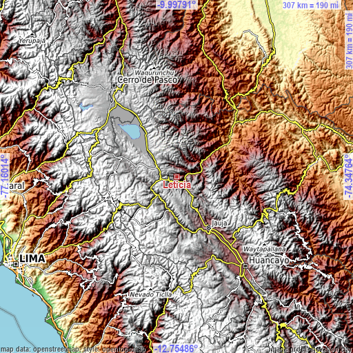
| \ | Map #1 | Topo.Map |
| Scale [m] | 3085..4263 m | × |
| Scale [ft] | 10121..13986 ft | × |
| Average | 3800.6 m = 12469 ft | × |
| Width | 9.58 km = 6 mi | 306.5 km = 190.4 mi |
| Height | 9.58 km = 6 mi | 306.6 km = 190.5 mi |
| ↑Max Latitude | -11.336635° | -9.99791° |
| Latitude at center | -11.37972° | -11.37972° |
| ↓Min Latitude | -11.422798° | -12.75486° |
| ← Min Longitude | -75.797835° | -77.16014° |
| Longitude center | -75.75389° | -75.75389° |
| →Max Longitude | -75.709945° | -74.34764° |
Nearby cities:
Cities around Leticia sort by population:
• Tarma elevation 3055 m
8.2 km,  122°
122°
• La Oroya 3765 m
22.2 km,  225°
225°
• Junín 4117 m
35.8 km,  313°
313°
• San Pedro de Cajas 4022 m
18.5 km,  320°
320°
• Huasahuasi 2737 m
17.2 km,  42°
42°
• Pomacancha 3801 m
42.3 km,  160°
160°
• Chacapalpa 3745 m
39.3 km,  180°
180°
• Paccha 3754 m
24.8 km,  245°
245°
• Tapo 3134 m
20.8 km,  93°
93°
• Palca 2738 m
20.5 km,  79°
79°
• Acobamba 2948 m
10.5 km,  73°
73°
• Palcamayo 3338 m
9.7 km,  347°
347°
Multilingual:
 En español:
Leticia elevación 3547 m.
 En France:
Leticia élévation 3547 m.
 Auf Deutsch:
Leticia höhe über dem Meeresspiegel ist 3547 m.

Sources and notes:
- [note 1] Map square and city borders are not equal. Map elevation data is calculated only from area inside that square.
- [src 1] Elevation data from geonames database provided with same terms of usage.
- [src 2] The elevation map of Leticia is generated using elevation data from NASA's 3 arcsec (90m) resolution SRTM data.
- [src 3] Base (background) map © OpenStreetMap contributors tiles are generated by Geofabrik and OpenTopoMap.
Copyright & License:
This Leticia Elevation Map is licensed under CC BY-SA. You may reuse any part from this page, if you give a proper credit by linking to this URL:
 More info on terms of use page.