Madean elevation
Madean (Lima region, Provincia de Yauyos), Peru elevation is 3265 meters and Madean elevation in feet is 10712 ft above sea level [src 1]. Madean is a seat of a third-order administrative division (feature code) with elevation that is 944 meters (3097 ft) bigger than average city elevation in Peru.
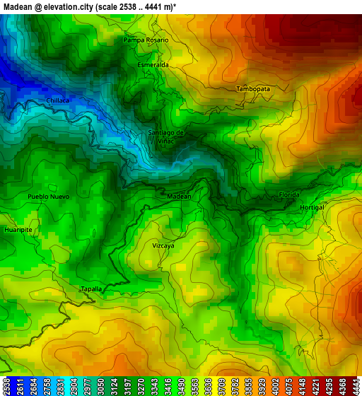
Below is the Elevation map of Madean, which displays elevation range with different colors. Scale of the first map is from 2538 to 4441 m (8327 to 14570 ft) with average elevation of 3509.3 meters (=11513 ft) [note 1]
These maps also provides idea of topography and contour of this city, they are displayed at different zoom levels. More info about maps, scale and edge coordinates you can find below images.
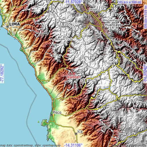
| \ | Map #1 | Topo.Map |
| Scale [m] | 2538..4441 m | × |
| Scale [ft] | 8327..14570 ft | × |
| Average | 3509.3 m = 11513 ft | × |
| Width | 9.52 km = 5.9 mi | 304.7 km = 189.3 mi |
| Height | 9.52 km = 5.9 mi | 304.8 km = 189.4 mi |
| ↑Max Latitude | -12.901608° | -11.57028° |
| Latitude at center | -12.94444° | -12.94444° |
| ↓Min Latitude | -12.987265° | -14.31106° |
| ← Min Longitude | -75.820615° | -77.18292° |
| Longitude center | -75.77667° | -75.77667° |
| →Max Longitude | -75.732725° | -74.37042° |
Nearby cities:
Cities around Madean sort by population:
• Arma elevation 3938 m
32.6 km,  125°
125°
• San Juan 2872 m
31.6 km,  154°
154°
• Tupe 2807 m
22.9 km,  351°
351°
• Huamatambo 3265 m
21.7 km, 152°
• Chupamarca 3372 m
21.5 km,  117°
117°
• Catahuasi 1172 m
20.4 km,  322°
322°
• Lincha 3489 m
20.2 km,  36°
36°
• Hongos 3191 m
14.8 km,  4°
4°
• Cacra 2778 m
14.7 km,  357°
357°
• Chocos 2710 m
9.9 km,  289°
289°
• Huangascar 2503 m
7.8 km,  310°
310°
• Viñac 3284 m
1.5 km, 351°
Multilingual:
 En español:
Madean elevación 3265 m.
 En France:
Madean élévation 3265 m.


Sources and notes:
- [note 1] Map square and city borders are not equal. Map elevation data is calculated only from area inside that square.
- [src 1] Elevation data from geonames database provided with same terms of usage.
- [src 2] The elevation map of Madean is generated using elevation data from NASA's 3 arcsec (90m) resolution SRTM data.
- [src 3] Base (background) map © OpenStreetMap contributors tiles are generated by Geofabrik and OpenTopoMap.
Copyright & License:
This Madean Elevation Map is licensed under CC BY-SA. You may reuse any part from this page, if you give a proper credit by linking to this URL:
 More info on terms of use page.