Mangas elevation
Mangas (Ancash, Provincia de Bolognesi), Peru elevation is 3550 meters and Mangas elevation in feet is 11647 ft above sea level [src 1]. Mangas is a seat of a third-order administrative division (feature code) with elevation that is 1229 meters (4032 ft) bigger than average city elevation in Peru.
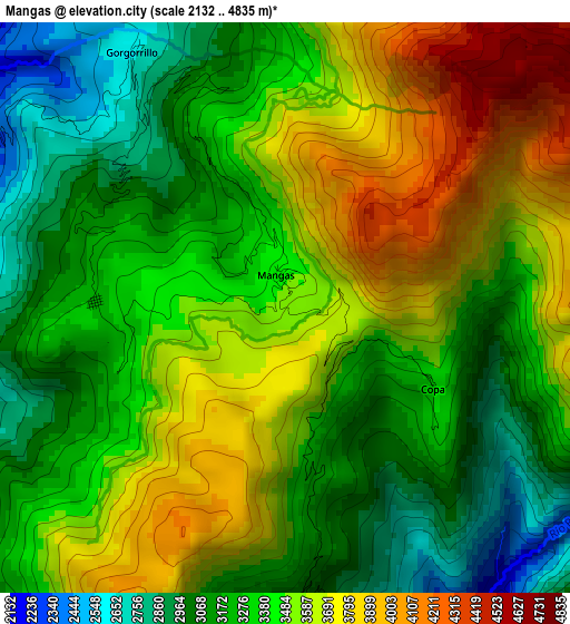
Below is the Elevation map of Mangas, which displays elevation range with different colors. Scale of the first map is from 2132 to 4835 m (6995 to 15863 ft) with average elevation of 3409.3 meters (=11185 ft) [note 1]
These maps also provides idea of topography and contour of this city, they are displayed at different zoom levels. More info about maps, scale and edge coordinates you can find below images.
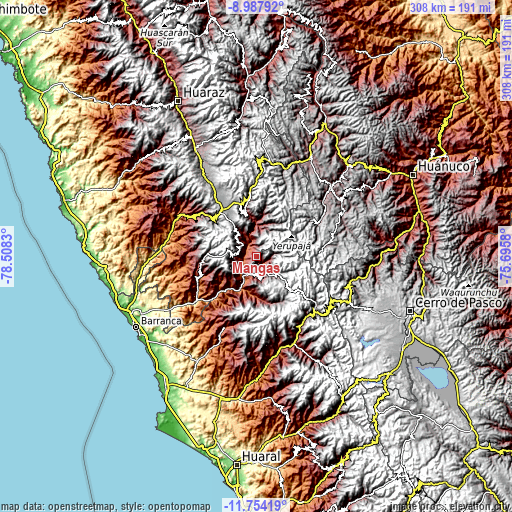
| \ | Map #1 | Topo.Map |
| Scale [m] | 2132..4835 m | × |
| Scale [ft] | 6995..15863 ft | × |
| Average | 3409.3 m = 11185 ft | × |
| Width | 9.61 km = 6 mi | 307.6 km = 191.1 mi |
| Height | 9.61 km = 6 mi | 307.6 km = 191.1 mi |
| ↑Max Latitude | -10.33088° | -8.98792° |
| Latitude at center | -10.37411° | -10.37411° |
| ↓Min Latitude | -10.417334° | -11.75419° |
| ← Min Longitude | -77.145995° | -78.5083° |
| Longitude center | -77.10205° | -77.10205° |
| →Max Longitude | -77.058105° | -75.6958° |
Nearby cities:
Cities around Mangas sort by population:
• Aquia elevation 3345 m
33.7 km,  352°
352°
• Ocros 3238 m
32.4 km,  264°
264°
• Huasta 3090 m
28.5 km, 347°
• Acas 3700 m
26.3 km,  249°
249°
• Gorgor 4066 m
24.4 km,  162°
162°
• Aco 2229 m
20.5 km,  228°
228°
• Ticllos 3644 m
16.5 km,  323°
323°
• Corpanqui 3381 m
14.5 km,  313°
313°
• Llipa 3009 m
11.4 km,  265°
265°
• Llaclla 2094 m
9.6 km,  330°
330°
• Canis 2457 m
8.3 km,  297°
297°
• Copa 3395 m
2.9 km,  122°
122°
Multilingual:
 En español:
Mangas elevación 3550 m.
 En France:
Mangas élévation 3550 m.


Sources and notes:
- [note 1] Map square and city borders are not equal. Map elevation data is calculated only from area inside that square.
- [src 1] Elevation data from geonames database provided with same terms of usage.
- [src 2] The elevation map of Mangas is generated using elevation data from NASA's 3 arcsec (90m) resolution SRTM data.
- [src 3] Base (background) map © OpenStreetMap contributors tiles are generated by Geofabrik and OpenTopoMap.
Copyright & License:
This Mangas Elevation Map is licensed under CC BY-SA. You may reuse any part from this page, if you give a proper credit by linking to this URL:
 More info on terms of use page.