Marcapata elevation
Marcapata (Cusco, Provincia de Quispicanchis), Peru elevation is 3038 meters and Marcapata elevation in feet is 9967 ft above sea level [src 1]. Marcapata is a seat of a third-order administrative division (feature code) with elevation that is 717 meters (2352 ft) bigger than average city elevation in Peru.
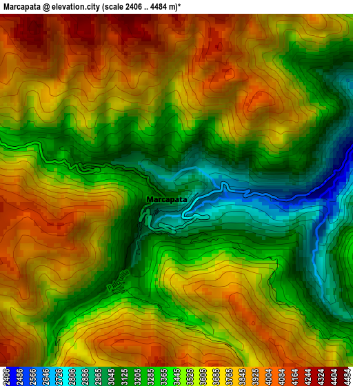
Below is the Elevation map of Marcapata, which displays elevation range with different colors. Scale of the first map is from 2406 to 4484 m (7894 to 14711 ft) with average elevation of 3526 meters (=11568 ft) [note 1]
These maps also provides idea of topography and contour of this city, they are displayed at different zoom levels. More info about maps, scale and edge coordinates you can find below images.
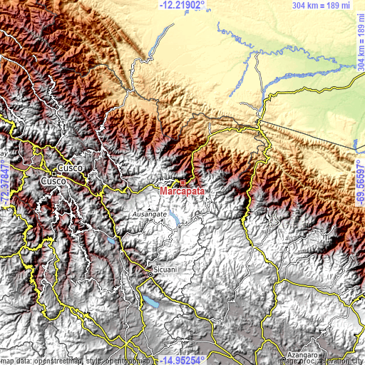
| \ | Map #1 | Topo.Map |
| Scale [m] | 2406..4484 m | × |
| Scale [ft] | 7894..14711 ft | × |
| Average | 3526 m = 11568 ft | × |
| Width | 9.5 km = 5.9 mi | 303.9 km = 188.8 mi |
| Height | 9.5 km = 5.9 mi | 304 km = 188.9 mi |
| ↑Max Latitude | -13.547001° | -12.21902° |
| Latitude at center | -13.58972° | -13.58972° |
| ↓Min Latitude | -13.632431° | -14.95254° |
| ← Min Longitude | -71.016165° | -72.37847° |
| Longitude center | -70.97222° | -70.97222° |
| →Max Longitude | -70.928275° | -69.56597° |
Nearby cities:
Cities around Marcapata sort by population:
• Cullcuyre elevation 3607 m
68 km,  214°
214°
• Lima Pampa 3565 m
68.1 km,  215°
215°
• Cusipata 3323 m
66.9 km,  238°
238°
• Quiquijana 3233 m
66.5 km,  247°
247°
• Pitumarca 3587 m
63.6 km,  228°
228°
• Ccatca 3765 m
63.5 km,  268°
268°
• Pillcopata 968 m
61.8 km,  340°
340°
• Lanlacuni Bajo 707 m
61.2 km,  78°
78°
• Ollachea 2907 m
58.5 km,  115°
115°
• Corani 4201 m
50.4 km,  128°
128°
• Quince Mil 642 m
46.4 km,  30°
30°
• Ocongate 3586 m
44.8 km,  264°
264°
Multilingual:
 En español:
Marcapata elevación 3038 m.
 En France:
Marcapata élévation 3038 m.
 Auf Deutsch:
Marcapata höhe über dem Meeresspiegel ist 3038 m.

Sources and notes:
- [note 1] Map square and city borders are not equal. Map elevation data is calculated only from area inside that square.
- [src 1] Elevation data from geonames database provided with same terms of usage.
- [src 2] The elevation map of Marcapata is generated using elevation data from NASA's 3 arcsec (90m) resolution SRTM data.
- [src 3] Base (background) map © OpenStreetMap contributors tiles are generated by Geofabrik and OpenTopoMap.
Copyright & License:
This Marcapata Elevation Map is licensed under CC BY-SA. You may reuse any part from this page, if you give a proper credit by linking to this URL:
 More info on terms of use page.