Pillpinto elevation
Pillpinto (Cusco, Provincia de Paruro), Peru elevation is 2867 meters and Pillpinto elevation in feet is 9406 ft above sea level [src 1]. Pillpinto is a seat of a third-order administrative division (feature code) with elevation that is 546 meters (1791 ft) bigger than average city elevation in Peru.
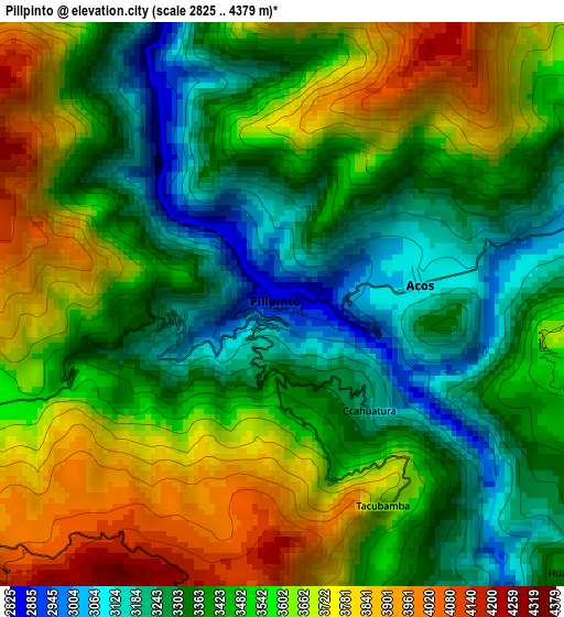
Below is the Elevation map of Pillpinto, which displays elevation range with different colors. Scale of the first map is from 2825 to 4379 m (9268 to 14367 ft) with average elevation of 3494.3 meters (=11464 ft) [note 1]
These maps also provides idea of topography and contour of this city, they are displayed at different zoom levels. More info about maps, scale and edge coordinates you can find below images.
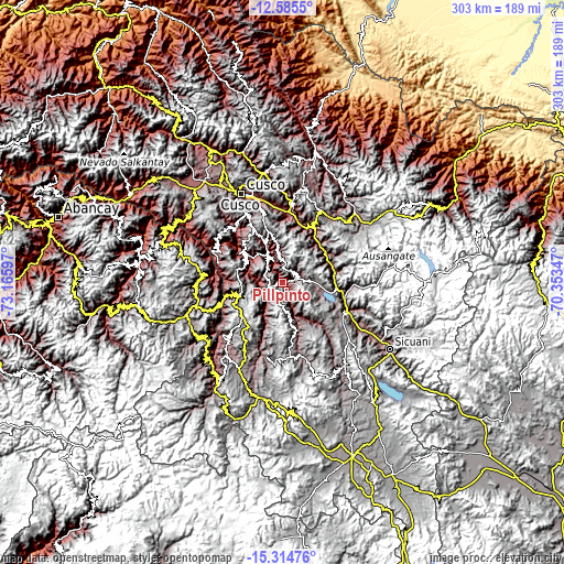
| \ | Map #1 | Topo.Map |
| Scale [m] | 2825..4379 m | × |
| Scale [ft] | 9268..14367 ft | × |
| Average | 3494.3 m = 11464 ft | × |
| Width | 9.48 km = 5.9 mi | 303.5 km = 188.6 mi |
| Height | 9.48 km = 5.9 mi | 303.5 km = 188.6 mi |
| ↑Max Latitude | -13.911518° | -12.5855° |
| Latitude at center | -13.95417° | -13.95417° |
| ↓Min Latitude | -13.996814° | -15.31476° |
| ← Min Longitude | -71.803665° | -73.16597° |
| Longitude center | -71.75972° | -71.75972° |
| →Max Longitude | -71.715775° | -70.35347° |
Nearby cities:
Cities around Pillpinto sort by population:
• Huaro elevation 3192 m
32.4 km,  24°
24°
• Paccaritambo 3621 m
30.2 km,  315°
315°
• Cusipata 3323 m
28.7 km,  79°
79°
• Quiquijana 3233 m
27.9 km,  58°
58°
• Capacmarca 3624 m
26.4 km,  256°
256°
• Paruro 3112 m
23.3 km,  335°
335°
• Pomacanchi 3677 m
22.3 km,  111°
111°
• Omacha 3963 m
13.2 km,  170°
170°
• Colcha 2809 m
12.3 km, 337°
• Acomayo 3290 m
9.5 km, 63°
• Accha 3580 m
7.5 km,  253°
253°
• Acos 3086 m
2.5 km, 81°
Multilingual:
 En español:
Pillpinto elevación 2867 m.
 En France:
Pillpinto élévation 2867 m.
 Auf Deutsch:
Pillpinto höhe über dem Meeresspiegel ist 2867 m.

Sources and notes:
- [note 1] Map square and city borders are not equal. Map elevation data is calculated only from area inside that square.
- [src 1] Elevation data from geonames database provided with same terms of usage.
- [src 2] The elevation map of Pillpinto is generated using elevation data from NASA's 3 arcsec (90m) resolution SRTM data.
- [src 3] Base (background) map © OpenStreetMap contributors tiles are generated by Geofabrik and OpenTopoMap.
Copyright & License:
This Pillpinto Elevation Map is licensed under CC BY-SA. You may reuse any part from this page, if you give a proper credit by linking to this URL:
 More info on terms of use page.