Santa Ana elevation
Santa Ana (Cusco, Provincia de La Convención), Peru elevation is 1646 meters and Santa Ana elevation in feet is 5400 ft above sea level [src 1]. Santa Ana is a populated place (feature code) with elevation that is 675 meters (2215 ft) smaller than average city elevation in Peru.
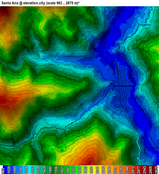
Below is the Elevation map of Santa Ana, which displays elevation range with different colors. Scale of the first map is from 963 to 2675 m (3159 to 8776 ft) with average elevation of 1497.7 meters (=4914 ft) [note 1]
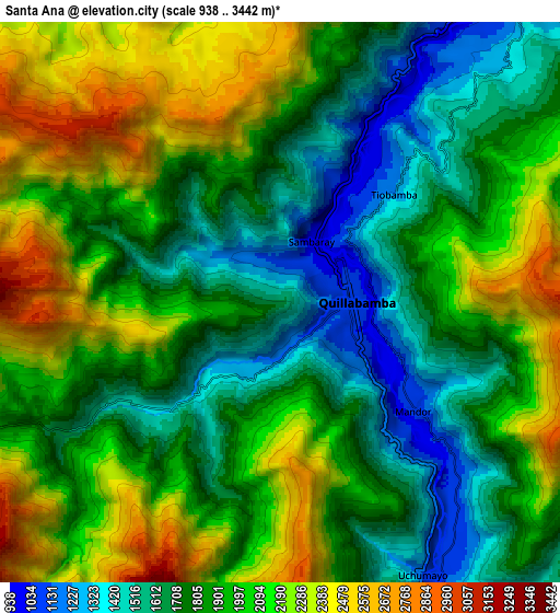
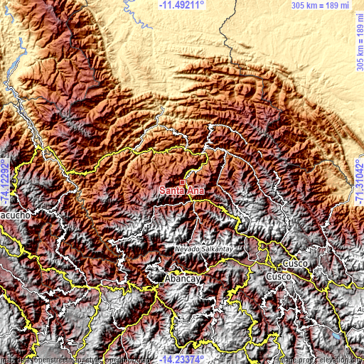
These maps also provides idea of topography and contour of this city, they are displayed at different zoom levels. More info about maps, scale and edge coordinates you can find below images.
| \ | Map #1 | Map #2 | Topo.Map |
| Scale [m] | 963..2675 m | 938..3442 m | × |
| Scale [ft] | 3159..8776 ft | 3077..11293 ft | × |
| Average | 1497.7 m = 4914 ft | 1928.2 m = 6326 ft | × |
| Width | 9.53 km = 5.9 mi | 19.05 km = 11.8 mi | 304.8 km = 189.4 mi |
| Height | 9.53 km = 5.9 mi | 19.05 km = 11.8 mi | 304.9 km = 189.5 mi |
| ↑Max Latitude | -12.823824° | -12.780972° | -11.49211° |
| Latitude at center | -12.86667° | -12.86667° | -12.86667° |
| ↓Min Latitude | -12.909508° | -12.952339° | -14.23374° |
| ← Min Longitude | -72.760615° | -72.804561° | -74.12292° |
| Longitude center | -72.71667° | -72.71667° | -72.71667° |
| →Max Longitude | -72.672725° | -72.628779° | -71.31042° |
Nearby cities:
Cities around Santa Ana sort by population:
• Ollantaytambo elevation 2851 m
65.6 km,  131°
131°
• Lares 3185 m
77.5 km,  109°
109°
• Curahuasi 2879 m
76 km,  178°
178°
• Limatambo 2607 m
74.3 km,  156°
156°
• Huanipaca 3316 m
74.2 km,  198°
198°
• Cachora 3055 m
72.6 km,  187°
187°
• Quebrada Honda 2449 m
53.6 km,  78°
78°
• Santa Teresa 1485 m
32.5 km, 155°
• Quellouno 765 m
30.7 km,  33°
33°
• Echarate 3034 m
18.3 km,  36°
36°
• Maranura 1126 m
12.1 km,  152°
152°
• Quillabamba 1054 m
2.6 km, 81°
Multilingual:
 En español:
Santa Ana elevación 1646 m.
 En France:
Santa Ana élévation 1646 m.
 Auf Deutsch:
Santa Ana höhe über dem Meeresspiegel ist 1646 m.

Sources and notes:
- [note 1] Map square and city borders are not equal. Map elevation data is calculated only from area inside that square.
- [src 1] Elevation data from geonames database provided with same terms of usage.
- [src 2] The elevation map of Santa Ana is generated using elevation data from NASA's 3 arcsec (90m) resolution SRTM data.
- [src 3] Base (background) map © OpenStreetMap contributors tiles are generated by Geofabrik and OpenTopoMap.
Copyright & License:
This Santa Ana Elevation Map is licensed under CC BY-SA. You may reuse any part from this page, if you give a proper credit by linking to this URL:
 More info on terms of use page.